| Pipestone Creek | |
|---|---|
 Pipestone Creek near Cromer, Manitoba | |
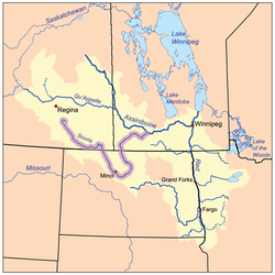
 The Red River drainage basin, with the Souris River highlighted | |
| Location | |
| Countries |
|
| Provinces | |
| Communities | |
| Physical characteristics | |
| Source | South of Grenfell |
| • location | Saskatchewan |
| Mouth | Oak Lake |
• location | Manitoba, Canada |
• elevation | 426 m (1,398 ft) |
| Basin size | 2,242 km2 (866 sq mi) |
| Basin features | |
| River system | Red River drainage basin |
| Tributaries | |
| • left | Little Pipestone Creek |
| • right | Montgomery Creek |
| [1][2] | |
Pipestone Creek[3] is a river[4] in the Souris River watershed.[5] Its flow begins in southeastern Saskatchewan, just south of the town of Grenfell and travels in a southeastern direction into Manitoba in the Westman Region where it empties into Oak Lake through the Oak Lake Marsh.
The Pipestone Creek is in a region called the Prairie Pothole Region of North America, which extends throughout three Canadian provinces and five U.S. states. It is also within Palliser's Triangle.[6] The topographical basin of Pipestone Creek's watershed ranges from 804 to 426 metres above sea level (asl), with a mean elevation of 650 asl.
"The Pothole Region is the result of the last Pleistocene glaciation and it is estimated that there are between 5 and 8 million wetlands or small depressions, which have an important biological role and impact on the ecosystem. It is estimated that the Pipestone Creek has a GDA (Gross Drainage Area) and EDA (Effective Drainage Area) of 2,242 km2 (866 sq mi) and 559 km2 (216 sq mi), respectively, and that near 11% of the watershed is covered by wetlands."[7]
Most of the waters that flow into the Pipestone Creek depend upon rains and melting snow. There are no large natural lakes in its watershed. Saskatchewan and Manitoba have waterflow agreements regulating how much water Saskatchewan must allow to flow down Pipestone Creek into Manitoba. Saskatchewan has always met its requirements.[8] Pipestone Creek and nearby Stony Creek[9] are the two main tributaries to Oak Lake Aquifer, which is an important source of water in south-west Manitoba.
- ^ "Natural Resources Canada-Canadian Geographical Names (Souris River)". Retrieved 29 August 2014.
- ^ "Atlas of Canada Toporama". Retrieved 29 August 2014.
- ^ "Place names - Pipestone Creek".
- ^ "Map of Pipestone Creek, Saskatchewan, River - Canada Geographical Names with Maps". www.geodata.us.
- ^ https://www.gov.mb.ca/water/watershed/iwmp/west_souris/documentation/public_input_summary.pdf [bare URL PDF]
- ^ "Drought in Palliser's Triangle | the Canadian Encyclopedia".
- ^ Perez-Valdivia, Cesar; Cade-Menun, Barbara; McMartin, Dena W. (2017). "Hydrological modeling of the pipestone creek watershed using the Soil Water Assessment Tool (SWAT): Assessing impacts of wetland drainage on hydrology". Journal of Hydrology: Regional Studies. 14: 109–129. Bibcode:2017JHyRS..14..109P. doi:10.1016/j.ejrh.2017.10.004.
- ^ "Prairie Provinces Water Board - Pipestone Creek". Prairie Provinces Water Board.
- ^ Government of Canada, Natural Resources Canada. "Place names - Stony Creek". www4.rncan.gc.ca.