| Platte River | |
|---|---|
 The Platte River near Platte City, Missouri | |
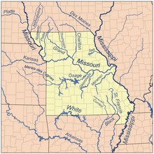
 Map of northern Missouri rivers | |
| Location | |
| Country | United States |
| State | Iowa, Missouri |
| District | Platte County, Missouri, Buchanan County, Missouri, Andrew County, Missouri, Nodaway County, Missouri, Worth County, Missouri, Taylor County, Iowa, Ringgold County, Iowa, Adams County, Iowa, Union County, Iowa |
| Physical characteristics | |
| Source | |
| • location | Creston, Iowa |
| • coordinates | 41°08′57″N 94°23′00″W / 41.14917°N 94.38333°W[1] |
| • elevation | 1,340 ft (410 m)[2] |
| Mouth | Missouri River |
• location | Platte City, Missouri |
• coordinates | 39°15′51″N 94°50′15″W / 39.26417°N 94.83750°W[1] |
• elevation | 738 ft (225 m)[1] |
| Discharge | |
| • location | Sharps Station, MO |
| • average | 1,783 cu/ft. per sec.[3] |

The Platte River is a tributary of the Missouri River, about 200 miles (320 km) long,[4] in southwestern Iowa and northwestern Missouri in the United States. It is sometimes known as the Little Platte River to distinguish it from the larger Platte River, also a tributary of the Missouri, in nearby Nebraska; the Platte River of Missouri itself has a tributary known as the "Little Platte River".[5][6][7]
- ^ a b c U.S. Geological Survey Geographic Names Information System: Platte River (Iowa and Missouri)
- ^ Orient, IA, 7.5 Minute Topographic Quadrangle, USGS, 1981
- ^ "USGS Surface Water data for Missouri: USGS Surface-Water Annual Statistics".
- ^ U.S. Geological Survey. National Hydrography Dataset high-resolution flowline data. The National Map, accessed March 30, 2011
- ^ Columbia Gazetteer of North America entry for "Little Platte River" Archived 2007-03-12 at the Wayback Machine
- ^ U.S. Geological Survey Geographic Names Information System: Platte River
- ^ U.S. Geological Survey Geographic Names Information System: Little Platte River