| The Poconos | |
|---|---|
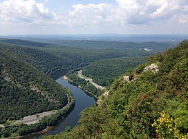
 View west from the Delaware Water Gap toward the Pocono Mountains in August 2013 | |
| Highest point | |
| Peak | Big Pine Hill |
| Elevation | 2,260–2,280 ft (690–690 m) |
| Coordinates | 41°13′44″N 75°22′24″W / 41.2290°N 75.3734°W |
| Naming | |
| Etymology | Lenape term for "stream between two mountains". |
| Geography | |
 | |
The Pocono Mountains, commonly referred to as the Poconos (/ˈpoʊkənoʊz/), are a geographical, geological, and cultural region in Northeastern Pennsylvania. They overlook the Delaware River and Delaware Water Gap to the east, Lake Wallenpaupack to the north, Wyoming Valley and the Coal Region to the west, and the Lehigh Valley to the south. The name Pocono is derived from the Munsee word Pokawachne, which means "Creek Between Two Hills".[1]
Much of the Poconos region lies within the Greater New York–Newark, NY–NJ–CT–PA Combined Statistical Area. The wooded hills and valleys have long been a popular recreation area, accessible within a two-hour drive to millions of metropolitan area residents, with many Pocono communities having resort hotels with fishing, hunting, skiing, and other sports facilities.
Although referred to usually as a mountain range, the area is actually a dissected plateau, a sub-section of the larger Allegheny Plateau, forming a 2,400-square-mile (6,200 km2) escarpment. The topological mountains are also a subrange of the Appalachian Mountains.
- ^ "gilwell.com: the Lenape / English Dictionary". gilwell.com.