| Pointe Mouillee State Game Area | |
|---|---|
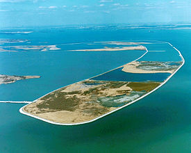
 Aerial view of the artificial barrier island | |
| Location | Monroe and Wayne counties Michigan |
| Nearest city | Rockwood, Michigan |
| Coordinates | 42°02′22″N 83°11′59″W / 42.03944°N 83.19972°W |
| Area | 7,483 acres (30.3 km2)[1] |
| Elevation | 571 feet (174 m)[2] |
| Established | 1945 |
| Governing body | Michigan Department of Natural Resources |
| Website | Official website |
| Pointe Mouillee Marsh Informational Designation | |
|---|---|
 | |
| Location | 37205 Pointe Mouillee Road Brownstown Township, Michigan |
| Coordinates | 42°02′39″N 83°12′00″W / 42.04417°N 83.20000°W |
| Designated | February 15, 1990 |
Pointe Mouillee State Game Area (/ˈpɔɪnt mwiːˈjeɪ/; point mwee-YAY or moo-LAY) is a state game area in the U.S. state of Michigan.[2] It encompasses 7,483 acres (30.3 km2) of hunting, recreational, and protected wildlife and wetland areas at the mouth of the Huron River at Lake Erie, as well as smaller outlying areas within the Detroit River. Pointe Mouillee State Game Area was established in 1945 and is administered by the Michigan Department of Natural Resources.[3]
- ^ Michigan DNR (26 October 2020). "List of State Wildlife/Game Areas" (PDF). p. 7. Retrieved November 12, 2020.
- ^ a b U.S. Geological Survey Geographic Names Information System: Pointe Mouillee State Game Area
- ^ Michigan DNR (3 September 2014). "Pointe Mouillee State Game Area" (PDF). Retrieved November 11, 2020.

