You can help expand this article with text translated from the corresponding article in French. (June 2014) Click [show] for important translation instructions.
|
Pokemouche | |
|---|---|
 | |
 | |
| Coordinates: 47°40′23″N 64°52′45″W / 47.67305556°N 64.87916667°W | |
| Country | |
| Province | |
| region | Acadian peninsula |
| County | Gloucester |
| Founded | 1812 |
| Constitution | 1984 |
| Founded by | Gilbert Duke, John Tophem |
| Area | |
| • Total | 22.79 km2 (8.80 sq mi) |
| Elevation | 23 m (75 ft) |
| Population (2011 | |
| • Total | 518 |
| • Density | 23/km2 (60/sq mi) |
| Demonym | Pokemouchois or Pokemouchian |
| language | |
| Time zone | UTC-4 (AST) |
| • Summer (DST) | UTC-3 (ADT) |
| Area code | +1-506 |
| georeference | 130110 |
| places of interest | Pokemouche River |
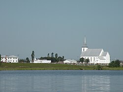
Pokemouche (IPA: [pɔkmuʃ]) was a Canadian local service district in Gloucester County, in the northeast of New Brunswick, in the Acadian peninsula; it included the communities of Cowans Creek, Pokemouche, and Upper Pokemouche. It is now part of the town of Caraquet.
Despite its population of only 518 inhabitants, the LSD plays an important role in transportation, the economy and culture of the region, and it is the site of several major projects.
The area around Pokemouche has been occupied for at least four thousand years by the Paleo-Indians, and for at least 3,000 years by Mi'kmaq people, who now have a settlement at the Burnt Church First Nation.
The current village was founded in 1812. Its main industry was originally forestry, but agriculture, as well as tourism centred on the Pokemouche River, now make up most of the local economy. A revival of the textile industry is also being considered.