| Ponmudi Dam | |
|---|---|
 Ponmudi dam and reservoir | |
| Country | India |
| Location | Idukki, Kerala |
| Coordinates | 9°57′37″N 77°03′24″E / 9.96028°N 77.05667°E |
| Purpose | Power |
| Status | Operational |
| Opening date | 1963 |
| Owner(s) | Kerala State Electricity Board |
| Dam and spillways | |
| Type of dam | Gravity dam |
| Impounds | Panniyar river |
| Height (foundation) | 57.60 m (189.0 ft) |
| Length | 288.8 m (948 ft) |
| Elevation at crest | 701.35 m (2,301.0 ft) |
| Spillways | 3 nos, radial gates, each of size 10.97 x6.4 m |
| Spillway type | Ogee type |
| Spillway capacity | 1416.3 m³/s |
| Reservoir | |
| Creates | Ponmudi Reservoir |
| Total capacity | 51,540,000 m3 (1.820×10⁹ cu ft) |
| Active capacity | 47,400,000 m3 (1.67×10⁹ cu ft) |
| Catchment area | 221.75 km2 (85.62 sq mi) |
| Maximum water depth | 708.66 m (2,325.0 ft) |
| Normal elevation | 707.75 m (2,322.0 ft) |
| Panniar Power Station | |
| Coordinates | 9°58′23″N 77°01′41″E / 9.97306°N 77.02806°E |
| Operator(s) | Kerala State Electricity Board |
| Commission date | 1963 |
| Turbines | 2 x 16.2 MW (Francis-type) |
| Installed capacity | 32.4 MW |
| Annual generation | 158 MU |
| Website Official website | |
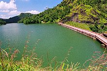
The Ponmudi Dam is a concrete gravity dam built across the Panniyar river which is a tributary of Periyar river at Konnathady panchayath of Konnathadi village in Idukki district of Kerala, India. The dam was constructed in 1963 as a part of a hydroelectric project. Construction was led by E.U.Philipose, Superintending Engineer, Kerala State Electricity Board. It has a length of 288.80 metres (947.5 ft).[1] The hydropower component of the dam has an installed capacity of 30 MW with firm power of 17 MW, generating 158 GWh annually.[2] Taluks through which the river flow are Udumbanchola, Devikulam, Kothamangalam, Muvattupuzha, Kunnathunadu, Aluva, Kodungalloor and Paravur.[1]
- ^ a b "Ponmudi Dam – KSEB Limited Dam Safety Organisation". Retrieved 4 August 2021.
- ^ "Ponmudi (Eb) D03300". Government of India.

