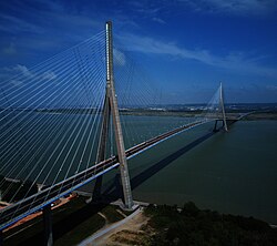
Pont de Normandie | |
|---|---|
 | |
| Coordinates | 49°26′09″N 0°16′28″E / 49.43583°N 0.27444°E |
| Carries | A29 autoroute |
| Crosses | Seine |
| Locale | Le Havre–Honfleur, France |
| Maintained by | Société des Autoroutes de Paris Normandie |
| Characteristics | |
| Design | Cable-stayed bridge M. Virlogeux, F. Doyelle, C. Lavigne |
| Total length | 2,143.21 metres (7,032 ft) |
| Width | 23.6 metres (77 ft) |
| Height | 214.77 metres (705 ft) |
| Longest span | 856 metres (2,808 ft) |
| Clearance below | 52 metres (171 ft) |
| History | |
| Constructed by | Bouygues Campenon Bernard Dumez Monberg & Thorsen Quillery Sogea Spie Batignolles |
| Opened | 1995 |
| Location | |
 | |
The Pont de Normandie (English: Normandy Bridge) is a cable-stayed road bridge that spans the river Seine linking Le Havre to Honfleur in Normandy, northern France. Its total length is 2,143.21 metres (7,032 ft) – 856 metres (2,808 ft) between the two piers. It is also the last bridge to cross the Seine before it empties into the ocean. It is a motorway toll bridge with a footpath and a narrow cycle lane in each direction allowing pedestrians and cyclists to cross the bridge free of charge, while motorcycling is also toll-free.[1]
- ^ Les tarifs, retrieved 6 August 2022