This article needs additional citations for verification. (August 2008) |
You can help expand this article with text translated from the corresponding article in French. (August 2013) Click [show] for important translation instructions.
|
Port-Louis | |
|---|---|
 A road in Port-Louis | |
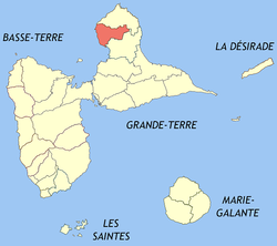
 Location of the commune (in red) within Guadeloupe | |
| Coordinates: 16°25′00″N 61°32′00″W / 16.4167°N 61.5333°W | |
| Country | France |
| Overseas region and department | Guadeloupe |
| Arrondissement | Pointe-à-Pitre |
| Canton | Petit-Canal |
| Intercommunality | CA Nord Grande-Terre |
| Government | |
| • Mayor (2020–2026) | Jean-Marie Hubert[1] |
| Area 1 | 44.24 km2 (17.08 sq mi) |
| Population (2021)[2] | 5,576 |
| • Density | 130/km2 (330/sq mi) |
| Time zone | UTC−04:00 (AST) |
| INSEE/Postal code | 97122 /97117 |
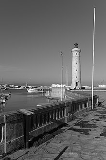
| Port-Louis Lighthouse | |
 | |
| Coordinates | 16°25′05.4″N 61°32′01.1″W / 16.418167°N 61.533639°W |
| Foundation | concrete base |
| Construction | concrete skeletal tower |
| Height | 10 metres (33 ft) |
| Shape | square prism skeletal tower with closed lower part, balcony and light[3][4] |
| Markings | yellow torwe with black horizontal band |
| Focal height | 10 metres (33 ft) |
| Range | 11 nautical miles (20 km; 13 mi) |
| Characteristic | Q (9) W 15s. |
| 1 French Land Register data, which excludes lakes, ponds, glaciers > 1 km2 (0.386 sq mi or 247 acres) and river estuaries. | |
Port-Louis (French pronunciation: [pɔʁ lwi] ; Guadeloupean Creole: Pòlwi) is a commune in the department of Guadeloupe, on the northwest of Grande-Terre.
- ^ "Répertoire national des élus: les maires" (in French). data.gouv.fr, Plateforme ouverte des données publiques françaises. 13 September 2022.
- ^ "Populations légales 2021" (in French). The National Institute of Statistics and Economic Studies. 28 December 2023.
- ^ Rowlett, Russ. "Lighthouses of Guadeloupe". The Lighthouse Directory. University of North Carolina at Chapel Hill. Retrieved 2016-08-30.
- ^ List of Lights, Buoys and Fog Signals Atlantic Coast. Retrieved 30 August 2016
