Port Hope | |
|---|---|
| Municipality of Port Hope | |
 Town hall | |
| Coordinates: 43°57′N 78°18′W / 43.950°N 78.300°W | |
| Country | Canada |
| Province | Ontario |
| County | Northumberland |
| Formed | 1789 |
| Named for | Henry Hope |
| Government | |
| • Type | Municipality |
| • Mayor | Olena Hankivsky |
| • Federal riding | Northumberland—Peterborough South |
| • Prov. riding | Northumberland—Peterborough South |
| Area | |
| • Land | 278.80 km2 (107.65 sq mi) |
| • Urban | 12.72 km2 (4.91 sq mi) |
| Population (2021)[1] | |
| • Total | 17,294 |
| • Density | 62.0/km2 (161/sq mi) |
| • Urban | 13,012 |
| • Urban density | 1,023.1/km2 (2,650/sq mi) |
| Time zone | UTC−05:00 (EST) |
| • Summer (DST) | UTC−04:00 (EDT) |
| Forward Sortation Area | |
| Area codes | 905, 289 and 365 |
| Website | www |
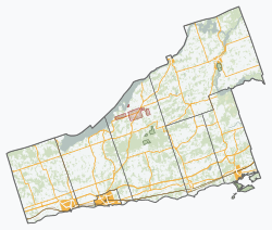
Port Hope is a municipality in Southern Ontario, Canada, approximately 109 km (68 mi) east of Toronto and about 159 km (99 mi) west of Kingston. It is located at the mouth of the Ganaraska River on the north shore of Lake Ontario, in the west end of Northumberland County. The private Trinity College School opened here in 1868.
- ^ a b "Port Hope, Ontario (Code 3514020) Census Profile". 2021 census. Government of Canada - Statistics Canada. Retrieved 2024-10-29.
- ^ a b "Port Hope Ontario [Population centre] Census Profile, 2021 Census of Population". www12.statcan.gc.ca. Government of Canada - Statistics Canada. Retrieved 29 October 2024.

