This article needs additional citations for verification. (July 2015) |
| Port Wakefield South Australia | |||||||||||||||
|---|---|---|---|---|---|---|---|---|---|---|---|---|---|---|---|
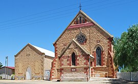
 The Uniting Church at Port Wakefield | |||||||||||||||
| Coordinates | 34°11′17″S 138°08′54″E / 34.18819°S 138.148325°E[1] | ||||||||||||||
| Population | 593 (UCL 2021)[2] | ||||||||||||||
| Postcode(s) | 5550[3] | ||||||||||||||
| Time zone | ACST (UTC+9:30) | ||||||||||||||
| • Summer (DST) | ACST (UTC+10:30) | ||||||||||||||
| Location | 99 km (62 mi) North West of Adelaide city centre via | ||||||||||||||
| LGA(s) | Wakefield Regional Council[4] | ||||||||||||||
| State electorate(s) | Narungga[5] | ||||||||||||||
| Federal division(s) | Grey | ||||||||||||||
| |||||||||||||||
| Footnotes | Adjoining localities[6] | ||||||||||||||
Port Wakefield (formerly Port Henry) is a town at the mouth of the River Wakefield, at the head of the Gulf St Vincent in South Australia. It was the first government town to be established north of the state capital, Adelaide. Port Wakefield is situated 98.7 kilometres (61.3 miles) from the Adelaide city centre on the Port Wakefield Highway section of the A1 National Highway.
Port Wakefield is a major stop on the Adelaide – Yorke Peninsula and Adelaide – Port Augusta road routes. Travellers between Adelaide and any of the Flinders Ranges, Yorke Peninsula, Eyre Peninsula or the Nullarbor Plain will likely travel through Port Wakefield. Due to its strategic location, Port Wakefield is known for its roadhouses and trucking stops.
Just north of the township there is a major forked intersection where the Yorke Peninsula traffic diverges west onto the Copper Coast Highway from the main Augusta Highway. The intersection is notorious for road accidents and traffic delays, especially at the end of holidays and long weekends.[7][8]
- ^ "Search results for 'Port Wakefield, LOCB' with the following datasets being selected – 'Suburbs and Localities', 'Counties', 'Government Towns', 'Local Government Areas', 'SA Government Regions', 'Gazetteer' and 'Roads'". Location SA Map Viewer. Government of South Australia. Retrieved 3 February 2019.
- ^ Australian Bureau of Statistics (28 June 2022). "Port Wakefield (urban centre and locality)". Australian Census 2021.
- ^ Port Wakefield Postcode. Australia Post. Retrieved on 2008-05-29
- ^ "Development Plan – Wakefield Council". Department of Planning Transport and Infrastructure. pp. 196, 239 & 248. Retrieved 24 July 2015.
- ^ Narungga (Map). Electoral District Boundaries Commission. 2016. Retrieved 1 March 2018.
- ^ "Search result for "Port Wakefield (Locality Bounded)" (Record no. SA0040720) with the following layers selected – "Suburbs and Localities" and " Place names (gazetteer)"". Property Location Browser. Government of South Australia. Archived from the original on 12 October 2016. Retrieved 16 November 2016.
- ^ Kelton, Sam (21 April 2014). "Two separate crashes, involving five cars, at Port Wakefield Rd intersection cause traffic pain for Easter drivers". The Advertiser. News Corp. Retrieved 11 August 2015.
- ^ Bishop, Ian (14 October 2014). "RAA Regional Roads Assessment – Yorke Peninsula". Royal Automobile Association. p. 6 (PDF page 11). Retrieved 11 August 2015.
The Copper Coast Highway is notorious for the extensive delays occurring at the intersection with the Augusta Highway and RAA recommends this intersection be addressed in the medium term.
