| Port of Ghent | |
|---|---|
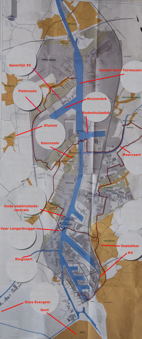
 Port of Ghent lay-out | |
 Click on the map for a fullscreen view | |
| Location | |
| Country | |
| Location | Ghent, |
| Coordinates | 51°06′21″N 3°44′24″E / 51.10583°N 3.74000°E |
| UN/LOCODE | BEGNE[1] |
| Statistics | |
| Annual cargo tonnage | 47,712 million tonnes (2014)[2] |
| Annual container volume | 530.823 TEU (2014)[2] |
| Website www.portofghent.be | |
The Port of Ghent is the third busiest seaport in Belgium, located in Ghent, East Flanders in the Flemish Region. The first port of Ghent was situated at the river Scheldt and later on at the Leie. Since the Middle Ages Ghent has sought for a connection to the sea. In the 13th century via the Lieve canal to the Zwin near Damme, in the 16th century via the Sassevaart, in the 17th century via the Ghent–Bruges canal. Since the 19th century, the Ghent–Terneuzen Canal connects the port via the Western Scheldt to the North Sea.[3] The port of Ghent is accessible by ships of the Panamax size, and in February 2015 the construction of a new lock at Terneuzen was announced, which will maintain near-parity with those of the Panama Canal expansion project.[4]


- ^ "UNLOCODE (BE) - BELGIUM". service.unece.org. UNECE. Retrieved 17 April 2020.
- ^ a b "Havengent.be". Archived from the original on 30 June 2015. Retrieved 17 February 2020.
- ^ "History of the port of Ghent". Archived from the original on 27 March 2004. Retrieved 3 March 2006.
- ^ Tony Slinn (6 February 2015). "Ghent to build $1Bn Terneuzen lock". IHS Maritime 360. IHS Inc. Archived from the original on 23 April 2015. Retrieved 23 April 2015.