| Port of Stockton | |
|---|---|
 Port of Stockton | |
 Click on the map for a fullscreen view | |
| Location | |
| Country | United States |
| Location | Stockton, California |
| Coordinates | 37°57′06″N 121°19′04″W / 37.95164°N 121.31764°W |
| UN/LOCODE | USSCK[1] |
| Details | |
| Opened | 1932 |
| Land area | 4,200 acres (17 km2) |
| No. of berths | 14 |
| Statistics | |
| Vessel arrivals | 278 (CY 2022) |
| Annual cargo tonnage | 4.4 million metric revenue tons (CY 2022)[2] |
| Value of cargo | US$1.6 billion (CY 2022) |
| Website www.portofstockton.com | |


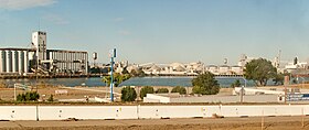
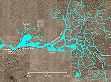
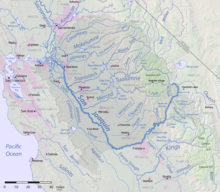
The Port of Stockton is a major deepwater port on the Stockton Ship Channel of the Pacific Ocean and an inland port located more than seventy nautical miles from the ocean, in Stockton, California on the Stockton Channel and San Joaquin River-Stockton Deepwater Shipping Channel (before it joins the Sacramento River to empty into Suisun Bay). By land acreage, the Port of Stockton is the 2nd largest port in the State of California and sits on about 4,200 acres (17 km2), and occupies an island in the Sacramento–San Joaquin River Delta, and a portion of a neighborhood known as Boggs Tract. It is governed by a commission appointed by the City of Stockton and San Joaquin County. The Port of Stockton is a self-sustaining economic powerhouse in the Central Valley and in 2023, contributed over $78 million in state and local tax funds.[3]
- ^ "UNLOCODE (US) - UNITED STATES". service.unece.org. Retrieved 24 March 2021.
- ^ "Port of Stockton sets record for shipping in 2014".
- ^ "Caltrans Port of Stockton Fact Sheet" (PDF). Retrieved April 7, 2014.