Porta Cordillera
Central Region | |
|---|---|
Tourism Region | |
| Nickname: Doorway to the Cordillera | |
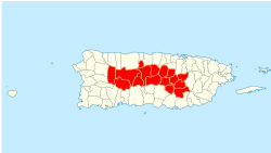
 Municipalities officially belonging to the Porta Cordillera region. | |
| Country | United States |
| Unincorporated territory | Puerto Rico |
| Founded by | Puerto Rico Tourism Company |
| Area | |
| • Total | 765.54 sq mi (1,982.7 km2) |
| Population | |
| • Total | 410,343 |
| • Density | 536.018/sq mi (206.958/km2) |
| Time zone | AST |
| Part of a series on |
| Tourism in Puerto Rico |
|---|
| Tourism Regions |
| Beaches |
| Caves |
| Cays and islets |
| Convention centers |
| Culture |
| Islands |
Porta Cordillera (Spanish for "dorway to the mountain range"), or simply Central Region (Región Central),[1] is a land-locked tourism region located in the central mountainous area of Puerto Rico. Porta Cordillera was officially launched in July 2012 by the Puerto Rico Tourism Company. It consists of 16 municipalities: Aguas Buenas, Cidra, Cayey, Comerío, Aibonito, Naranjito, Barranquitas, Corozal, Orocovis, Morovis, Ciales, Jayuya, Florida, Utuado, Adjuntas and Lares.[2]
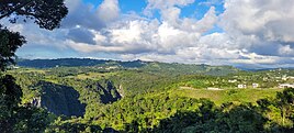
The name Porta Cordillera translates to "Doorway to the Cordillera", where "cordillera" refers to Puerto Rico's Cordillera Central, the main central mountain range of the island. Despite the name, some of its constituent municipalities are located in the Northern Puerto Rico karst country, with municipalities such as Ciales and Utuado spanning both topographic regions and others such as Florida located entirely outside of the Cordillera Central. This tourism region is known for its stunning nature reserves, forests, coffee plantations, lakes, rivers and caves, as well as its protected karst areas. The region is also home to the highest town in Puerto Rico, the highest point in Puerto Rico (shared with Porta Caribe to the south) and to one of the largest and deepest canyons in the Caribbean. The Ruta Panorámica scenic route notably cuts through the heart of this region.[3]
- ^ "The Regions of Puerto Rico | Discovering Puerto Rico". 2013-04-19. Retrieved 2023-08-12.
- ^ Tourism Co. brands 16-town mountain region as ‘Porta Cordillera’. Michelle Kantrow. News Is My Business. 10 July 2012. Retrieved 20 October 2013.
- ^ “Porta Cordillera”, nueva zona turística de la Isla. Archived 2012-07-12 at the Wayback Machine 8 July 2012. Inter News Service. El Vocero de Puerto Rico. San Juan, Puerto Rico. Retrieved 20 October 2013.


