Portarlington
Cúil an tSúdaire | |
|---|---|
Town | |
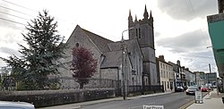
 St Paul's Church is on French Church Street off Portarlington's market square | |
| Coordinates: 53°09′36″N 7°11′24″W / 53.160°N 7.190°W | |
| Country | Ireland |
| Province | Leinster |
| County | County Laois & County Offaly |
| Elevation | 66 m (217 ft) |
| Population | |
| • Urban | 9,288 |
| Time zone | UTC±0 (WET) |
| • Summer (DST) | UTC+1 (IST) |
| Eircode routing key | R32 |
| Telephone area code | +353(0)57 |
| Irish Grid Reference | N540125 |

Portarlington, historically called Cooletoodera[2] (from Irish: Cúil an tSúdaire, meaning 'nook of the tanner'), is a town on the border of County Laois and County Offaly, Ireland. The River Barrow forms the border. Portarlington is around 70 kilometres (43 mi) west of Dublin. The town was recorded in the 2022 census as having a population of 9,288.[1]
- ^ a b "Interactive Data Visualisations: Towns: Portarlington". Census 2022. Central Statistics Office. Retrieved 30 September 2023.
- ^ "Portarlington / Cúil an tSúdaire". logainm.ie. Placenames Database of Ireland. Retrieved 17 June 2019.
