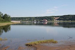
Portneuf-sur-Mer | |
|---|---|
 | |
 Location within La Haute-Côte-Nord RCM | |
| Coordinates: 48°37′N 69°06′W / 48.617°N 69.100°W[1] | |
| Country | Canada |
| Province | Quebec |
| Region | Côte-Nord |
| RCM | La Haute-Côte-Nord |
| Constituted | September 12, 1902 |
| Government | |
| • Mayor | Jean-Maurice Tremblay |
| • Federal riding | Montmorency—Charlevoix —Haute-Côte-Nord |
| • Prov. riding | René-Lévesque |
| Area | |
| • Total | 210.12 km2 (81.13 sq mi) |
| • Land | 181.90 km2 (70.23 sq mi) |
| Population (2021)[3] | |
| • Total | 612 |
| • Density | 3.4/km2 (9/sq mi) |
| • Pop (2016-21) | |
| • Dwellings | 357 |
| Time zone | UTC−5 (EST) |
| • Summer (DST) | UTC−4 (EDT) |
| Postal code(s) | |
| Area code(s) | 418 and 581 |
| Highways | |
| Website | portneuf-sur-mer |
Portneuf-sur-Mer is a municipality in the Côte-Nord region of the province of Quebec in Canada. The municipality is located at the mouth of the Portneuf River on the St. Lawrence River.
The municipality was known as Sainte-Anne-de-Portneuf prior to January 31, 2004.[4]
- ^ Cite error: The named reference
toponymiewas invoked but never defined (see the help page). - ^ a b "Répertoire des municipalités: Geographic code 95040". www.mamh.gouv.qc.ca (in French). Ministère des Affaires municipales et de l'Habitation. Retrieved 2024-07-03.
- ^ a b "Portneuf-sur-Mer (Code 2495040) Census Profile". 2021 census. Government of Canada - Statistics Canada. Retrieved 2024-07-03.
- ^ "Archived copy" (PDF). stat.gouv.qc.ca. Archived from the original (PDF) on 30 December 2006. Retrieved 30 June 2022.
{{cite web}}: CS1 maint: archived copy as title (link)


