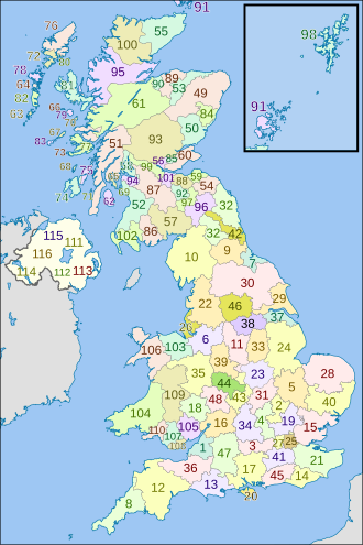
The postal counties of the United Kingdom, now known as former postal counties,[1] were postal subdivisions in routine use by the Royal Mail until 1996.[2] The purpose of the postal county – as opposed to any other kind of county – was to aid the sorting of mail by differentiating between similar post towns. Since 1996 this has been done by using the outward code (first half) of the postcode instead. For operational reasons, the former postal counties, although broadly based on the counties of the United Kingdom, did not match up with their boundaries; in some cases there were significant differences. The boundaries changed over time as post towns were created or amended.
According to the Royal Mail, the former postal county data no longer forms part of postal addresses. It was removed from the Postcode Address File database in 2000 and does not form part of its code of practice for changing addresses.[3] Despite this, county data is routinely sold to companies, ostensibly to let them cleanse their own address data. As the former postal county data was the last to be in routine use, some organisations have continued to use this obsolete data as part of postal addresses. In 2009, the Royal Mail code of practice consultation included discussion of the possible replacement of the currently supplied "alias data" with an up-to-date county information data field.[4] In 2010, the regulator advised Royal Mail to cease supply of county data altogether,[5] and a timetable was put in place for this to occur between 2013 and 2016.[6]
- ^ Royal Mail Programmers' Guide, Edition 7, version 5.0, Royal Mail Group Ltd, 2009, p.65
- ^ "Pembrokeshire (Royal Mail Database) c218WH". Hansard. 23 June 2009. Retrieved 23 July 2009.
- ^ Cite error: The named reference
codewas invoked but never defined (see the help page). - ^ Postcomm, Review of Royal Mail's Postcode Address File Code of Practice Consultation Archived 3 September 2009 at the Wayback Machine, 28 May 2009
- ^ "Changes to postcode address file Code of Practice under Condition 22 of Royal Mail's licence: A decision document" (PDF). Postal Services Commission (Postcomm). May 2010. Archived from the original (PDF) on 20 July 2011. Retrieved 12 June 2010.
- ^ Hope, Christopher (31 July 2010). "Counties to be axed from postal addresses". The Daily Telegraph. London. Retrieved 2 August 2010.
