| Powell River | |
|---|---|
 The Powell River near Harrogate in Claiborne County, Tennessee | |
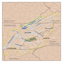
 The Powell drainage basin | |
| Location | |
| Country | United States |
| State | Virginia, Tennessee |
| Physical characteristics | |
| Source | Indian Mountain in Wise County, Virginia |
| • coordinates | 37°01′51″N 82°42′25″W / 37.03083°N 82.70694°W[1] |
| • elevation | 3,490 ft (1,060 m)[1] |
| Mouth | Clinch River in Claiborne County, Tennessee |
• coordinates | 36°17′49″N 84°01′34″W / 36.29694°N 84.02611°W[2] |
• elevation | 1,020 ft (310 m)[1] |
| Length | 195.5 mi (314.6 km)[3] |
| Basin size | 954 sq mi (2,470 km2)[4] |
| Discharge | |
| • location | US-25E bridge near Arthur, Tennessee, 65.4 miles (105.3 km) above the mouth(mean for water years 1919-1979)[5] |
| • average | 1,157 cu ft/s (32.8 m3/s)(mean for water years 1919-1979)[5] |
| • minimum | 47 cu ft/s (1.3 m3/s) January 1940[5] |
| • maximum | 59,500 cu ft/s (1,680 m3/s) April 1977[5] |
The Powell River is a 195-mile-long river in the United States that rises in Southwest Virginia and flows southwest into East Tennessee.
The South Fork of the river rises in rural Wise County, Virginia, near the Laurel Grove community northwest of Norton and flows for several miles before the confluence with Roaring Fork in the Kent Junction community. From Kent Junction the river flows until it meets the North Fork of the river near Woodway, Virginia. The North Folk originates near Keokee, Virginia. The river flows past Big Stone Gap, Virginia, and then runs nearly the entire length of Lee County, Virginia. It drains approximately 954 square miles (2,471 km2) in both Virginia and Tennessee before reaching its confluence with the Clinch River in the Norris Lake reservoir at the site of the town of Grantsboro, Tennessee.
The Powell River was named for Ambrose Powell who accompanied the exploration party of Dr. Thomas Walker in the mid-18th century. Legend has it that his name appeared so frequently carved on trees in the valley of this river that later explorers and early pioneers came to call the stream "Powell's River" and the valley "Powell's Valley".[6]
The Powell River was designated by the Environmental Protection Agency (EPA) as the “second most biologically diverse aquatic system in the nation.”[7] The Powell is under pressure from the effects of mining (including strip mining), logging and associated road-building.[7]
Lincoln Memorial University operates the Powell River Aquatic Research Station, which is located where Tennessee State Route 63 crosses the river at the Brooks Bridge in Claiborne County, Tennessee. The center allows for on-site research of water quality, flora, fauna and related habitat.[8]
Fishing in the Powell River can be great in some areas; in Wise County the Virginia Department of Wildlife Resources stocks trout in the shallow rushing waters of the Middle Fork under a "delayed harvest" designation.[9] Downstream from Lee County, the river is home to smallmouth bass, largemouth bass, red eye bass, bluegill, carp, red horses, walleye, sauger and even musky. A lot of people kayak the river and even wade to fish.[citation needed]
In July 2024, the Tennessee Valley Authority (TVA) and the Virginia Department of Wildlife Resources (DWR) celebrated improved stream access to the Powell River in Jonesville, Virginia. After completing the projects, kayakers and anglers could easily get to the water in three areas along the Powell River that had been inaccessible by public land areas.[10]
- ^ a b c U.S. Geological Survey Geographic Names Information System: Powell River
- ^ U.S. Geological Survey. Demory, TN. 1:24,000. Coordinates given for the mouth in GNIS (36.4996300, -83.672000) refer to a point 56 miles upstream from the river's mouth.
- ^ Obtained from adding the length of the Tennessee section of the river, indicated as 115.5 miles on USGS topographical maps, to the Virginia section of the river, indicated as 80 miles on the Virginia Department of Game and Inland Fisheries website.
- ^ Powell River Watershed (06010206) of the Tennessee River Basin: Water Quality Management Plan, Tennessee Department of Environment and Conservation website, 2008. Retrieved: 8 June 2015.
- ^ a b c d United States Geological Survey, Water Resources Data Tennessee: Water Year 1979, Water Data Report TN-79-1, p. 199. Gaging station 03532000.
- ^ Collins, Lewis (1877). History of Kentucky. p. 416.
- ^ a b Jefferson National Forest (N.F.), Revised Land and Resource Management Plan: Environmental Impact Statement. United States Forest Service. January 2004. pp. 4–32. Retrieved 28 November 2022.
- ^ LMU OPENS POWELL RIVER AQUATIC RESEARCH STATION Archived 2011-07-19 at the Wayback Machine, Lincoln Memorial University press release
- ^ "Delayed Harvest Waters". Virginia Department of Wildlife Resources. 2022. Retrieved 28 November 2022.
- ^ Lee, Murry (July 24, 2024). "Water access improved along Powell River in Lee County". www.wjhl.com/. Retrieved October 23, 2024.