Pozo Almonte | |
|---|---|
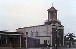
 Church of Pozo Almonte | |
| Coordinates (city): 20°16′S 69°48′W / 20.267°S 69.800°W | |
| Country | |
| Region | |
| Province | Tamarugal |
| Founded | 1875 |
| Government | |
| • Type | Municipal council |
| Area | |
| • Total | 13,765.8 km2 (5,315.0 sq mi) |
| Elevation | 1,072 m (3,517 ft) |
| Population (2017 Census)[1] | |
| • Total | 15,711 |
| • Density | 1.1/km2 (3.0/sq mi) |
| • Urban | 8,987 |
| • Rural | 6,724 |
| Demonym | Pocino |
| Sex | |
| • Men | 6,521 |
| • Women | 4,309 |
| Time zone | UTC−4 (CLT) |
| • Summer (DST) | UTC−3 (CLST) |
| Climate | BWk |
| Website | Official website (in Spanish) |
Pozo Almonte (Spanish pronunciation: [ˈposo alˈmonte]) is a city and commune of Chile located in the interior of Atacama Desert. It has been the capital of Tamarugal Province since this province was established in 2007. The city is located at 52 km (32 mi) from Tacapacá Region's capital, Iquique. It has over 15,000 inhabitants. The commune has an area of 13,766 km (8,554 mi) and borders the following communes: Iquique, Alto Hospicio, Huara, Pica, María Elena and Tocopilla (the last two being in Tocopilla Province).
- ^ a b c "National Statistics Institute" (in Spanish). Retrieved 3 January 2019.


