Preah Vihear
ព្រះវិហារ | |
|---|---|
| Preah Vihear Province ខេត្តព្រះវិហារ | |
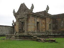
 Preah Vihear Temple, from which the province received its name | |
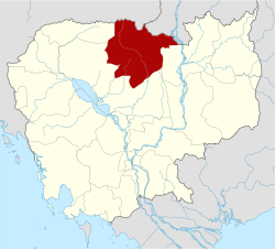
 Map of Cambodia highlighting Preah Vihear | |
| Coordinates: 13°47′N 104°58′E / 13.783°N 104.967°E | |
| Country | |
| ICJ ruling | 15 June 1962 |
| Provincial status | 22 July 1964[1] |
| Named for | Preah Vihear Temple |
| Capital | Preah Vihear |
| Government | |
| • Governor | Kim Rithy (CPP) |
| • National Assembly | 1 / 125
|
| Area | |
• Total | 13,788 km2 (5,324 sq mi) |
| • Rank | 3rd |
| Population (2023)[2] | |
• Total | |
| • Rank | 19th |
| • Density | 18/km2 (50/sq mi) |
| • Rank | 22nd |
| Time zone | UTC+7 (ICT) |
| Dialing code | +855 |
| ISO 3166 code | KH-13 |
| Website | www |
Preah Vihear (Khmer: ព្រះវិហារ, UNGEGN: Preăh Vĭhar, ALA-LC: Braḥ Vihār [preah ʋihiə]; lit. 'sacred sanctuary') is a province (khaet) of Cambodia. It borders the provinces of Oddar Meanchey and Siem Reap to the west, Kampong Thom to the south and Stung Treng to the east. Its northern boundary forms part of Cambodia's international border with Thailand and Laos. Its capital is Preah Vihear.
- ^ "History of Preah Vihear Province". preahvihear.gov.kh (in Khmer). Retrieved 26 June 2020.
- ^ "General Population Census of the Kingdom of Cambodia 2019 – Final Results" (PDF). National Institute of Statistics. Ministry of Planning. 26 January 2021. Retrieved 3 February 2021.
