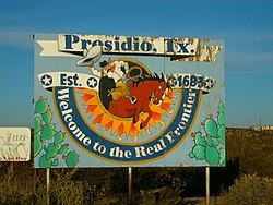
Presidio, Texas | |
|---|---|
 Signpost outside the city of Presidio, Texas | |
 Location of Presidio, Texas | |
| Coordinates: 29°33′41″N 104°21′59″W / 29.56139°N 104.36639°W[1] | |
| Country | United States |
| State | Texas |
| County | Presidio |
| Area | |
| • Total | 2.58 sq mi (6.67 km2) |
| • Land | 2.58 sq mi (6.67 km2) |
| • Water | 0.00 sq mi (0.00 km2) |
| Elevation | 2,579 ft (786 m) |
| Population (2020) | |
| • Total | 3,264 |
| • Density | 1,300/sq mi (490/km2) |
| Time zone | UTC-6 (Central (CST)) |
| • Summer (DST) | UTC-5 (CDT) |
| ZIP codes | 79845-79846 |
| Area code | 432 |
| FIPS code | 48-59396[3] |
| GNIS feature ID | 2411489[1] |
| Website | City of Presidio |
Presidio is a city in Presidio County, Texas, United States. It is situated on the Rio Grande (Río Bravo del Norte) River, on the opposite side of the U.S.–Mexico border from Ojinaga, Chihuahua. The name originates from Spanish and means "fortress". The population was 3,264 at the 2020 census.[4]
Presidio is on the Farm to Market Road 170, and U.S. Route 67, 18 miles (29 km) south of Shafter in Presidio County. Presidio is approximately 250 miles (400 km) southeast of El Paso, 240 miles (390 km) southwest of Odessa, and 145 miles (233 km) northeast of Chihuahua City.
- ^ a b c U.S. Geological Survey Geographic Names Information System: Presidio, Texas
- ^ "2019 U.S. Gazetteer Files". United States Census Bureau. Retrieved August 7, 2020.
- ^ "U.S. Census website". United States Census Bureau. Retrieved January 31, 2008.
- ^ Cite error: The named reference
:0was invoked but never defined (see the help page).