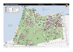
Presidio of San Francisco | |
|---|---|
 A map of the Presidio | |
| Coordinates: 37°47′53″N 122°27′57″W / 37.79806°N 122.46583°W | |
| Country | |
| State | |
| City-county | San Francisco |
| Fortified | September 17, 1776 |
| Government | |
| • Type | Board of Supervisors |
| Area | |
| • Total | 2.4 sq mi (6 km2) |
| Population (2019)[1] | |
| • Total | 4,226 |
| • Density | 1,800/sq mi (680/km2) |
| Time zone | UTC−8 (Pacific) |
| • Summer (DST) | UTC−7 (PDT) |
| ZIP code | 94129 |
| Area codes | 415/628 |
Presidio of San Francisco | |
| Area | 1,480 acres (6.0 km2)[3] |
| Built | 1776 |
| Architect | Spanish/Mexico/United States Army |
| Architectural style | Spanish Colonial, Spanish Revival, Colonial Revival, Classical Revival |
| Website | Presidio of San Francisco Presidio Trust |
| NRHP reference No. | 66000232[2] |
| CHISL No. | 79 |
| Significant dates | |
| Added to NRHP | October 15, 1966 |
| Designated NHL | June 13, 1962[5] |
| Designated CHISL | 1933[4] |
The Presidio of San Francisco (originally, El Presidio Real de San Francisco or The Royal Fortress of Saint Francis) is a park and former U.S. Army post on the northern tip of the San Francisco Peninsula in San Francisco, California, and is part of the Golden Gate National Recreation Area.
It had been a fortified location since September 17, 1776, when New Spain established the presidio to gain a foothold in Alta California and the San Francisco Bay. It passed to Mexico in 1820, which in turn passed to the United States in 1848.[6] As part of a military reduction program under the Base Realignment and Closure (BRAC) process from 1988, Congress voted to end the Presidio's status as an active military installation of the U.S. Army.[7] On October 1, 1994, it was transferred to the National Park Service, ending 219 years of military use and beginning its next phase of mixed commercial and public use.[8]
In 1996, the United States Congress created the Presidio Trust to oversee and manage the interior 80% of the park's lands, with the National Park Service managing the coastal 20%.[9] In a first-of-its-kind structure, Congress mandated that the Presidio Trust make the Presidio financially self-sufficient by 2013. The Presidio achieved the goal in 2005, eight years ahead of the deadline.[10]
The park has many wooded areas, hills, and scenic vistas overlooking the Golden Gate Bridge, San Francisco Bay, and the Pacific Ocean. It was recognized as a California Historical Landmark in 1933 and as a National Historic Landmark in 1962.[5][4]
- ^ a b "Census Tract 601, San Francisco, CA". Retrieved October 27, 2020.
- ^ "National Register Information System". National Register of Historic Places. National Park Service. April 15, 2008.
- ^ "Presidio of San Francisco" (PDF). National Park Service. Archived from the original (PDF) on 2009-03-25. Retrieved 2012-01-17.
- ^ a b "Presidio of San Francisco". Office of Historic Preservation, California State Parks. Retrieved 2012-10-14.
- ^ a b NHL Summary.
- ^ "Under Three Flags" (PDF). National Park Service. Retrieved 2012-01-17.
- ^ U.S. Army Medical Research and Materiel Command Headquarters (2008). USAMRMC: 50 Years of Dedication to the Warfighter : 1958-2008. p. 121.
- ^ "Presidio of San Francisco Post to Park transition". National Park Service. Retrieved 2008-12-20.
- ^ "The Presidio Trust". Archived from the original on February 14, 2012.
- ^ Levy, Dan (June 19, 2005). "A Green Belt in The Black". San Francisco Chronicle. Retrieved 2008-12-20.
