Native name: ᐅᑉᐸᐃᑦ (Appait) | |
|---|---|
 | |
| Etymology | Named after Prince Leopold of Saxe-Coburg-Saalfeld in 1819 |
| Geography | |
| Location | Northern Canada |
| Coordinates | 74°N 90°W / 74°N 90°W |
| Archipelago | Arctic Archipelago |
| Area | 68 km2 (26 sq mi) |
| Length | 10.9 km (6.77 mi) |
| Width | 9.2 km (5.72 mi) |
| Highest elevation | 306 m (1004 ft) |
| Administration | |
Canada | |
| Territory | Nunavut |
| Region | Qikiqtaaluk |
| Demographics | |
| Population | Uninhabited |
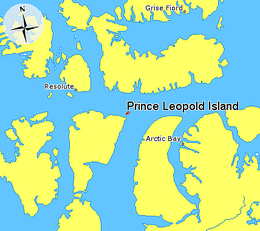
Prince Leopold Island (Inuktitut: ᐅᑉᐸᐃᑦ, Appait)[1] is an island in the Qikiqtaaluk Region of Nunavut, Canada. It is located in Lancaster Sound at the junction of Prince Regent Inlet and Barrow Strait. Somerset Island is situated 13 km (8.1 mi) to the southwest; Port Leopold, an abandoned trading post, is the closest landmark. The island is significant as a summer habitat and breeding ground for large populations of several arctic bird species.
- ^ "Siqiniq (Prince Leopold Island Migratory Bird Sanctuary)". ACMC Nunavut. Retrieved 2022-12-06.

