Princeton, Massachusetts | |
|---|---|
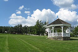
 Town Common in Princeton, MA | |
 Location in Worcester County and the state of Massachusetts. | |
| Coordinates: 42°26′55″N 71°52′40″W / 42.44861°N 71.87778°W | |
| Country | United States |
| State | Massachusetts |
| County | Worcester |
| Settled | 1743 |
| Incorporated | 1771 |
| Government | |
| • Type | Open town meeting |
| • Town Administrator | Sherry Patch |
| • Board of Selectmen | Karen Cruise, Chair Richard Bisk, Vice Chair Robert Cumming, Member |
| Area | |
| • Total | 35.8 sq mi (92.8 km2) |
| • Land | 35.4 sq mi (91.8 km2) |
| • Water | 0.4 sq mi (1.0 km2) |
| Elevation | 1,175 ft (358 m) |
| Population (2020) | |
| • Total | 3,495 |
| • Density | 98/sq mi (38/km2) |
| Time zone | UTC−5 (Eastern) |
| • Summer (DST) | UTC−4 (Eastern) |
| ZIP Code | 01541 |
| Area code | 351/978 |
| FIPS code | 25-55395 |
| GNIS feature ID | 0618380 |
| Website | town.princeton.ma.us |
Princeton is a town in Worcester County, Massachusetts, United States. It is bordered on the east by Sterling and Leominster, on the north by Westminster, on the northwest by Hubbardston, on the southwest by Rutland, and on the southeast by Holden. The preeminent landmark within Princeton is Mount Wachusett, which straddles the line between Princeton and Westminster but the entrance to which is within Princeton. According to tradition, in 1675, Mary Rowlandson was ransomed upon Redemption Rock, now within the town of Princeton, by King Philip. The population was 3,495 at the 2020 census.[1] Princeton is a rural exurb, serving as a bedroom commuter town for nearby cities such as Worcester, Gardner, and Boston.
- ^ "Census - Geography Profile: Princeton town, Worcester County, Massachusetts". United States Census Bureau. Retrieved November 12, 2021.

