Providence Metropolitan Area | |
|---|---|
| Providence–Warwick, RI-MA Metropolitan Statistical Area | |
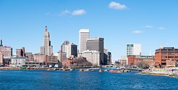
 The skyline of Providence, Rhode Island | |
 | |
| Country | |
| State | |
| Largest city | Providence, RI |
| Other cities | - New Bedford, MA - Fall River, MA - Warwick, RI - Pawtucket, RI - Cranston, RI |
| Area | |
| • Total | 1,635.76 sq mi (4,236.6 km2) |
| Highest elevation | 812 ft (247.5 m) |
| Lowest elevation | 0 ft (0 m) |
| Population (2005 est.) | |
| • Total | 1,612,989 |
| • Rank | 38th in the U.S. |
| • Density | 1,006.21/sq mi (380.78/km2) |
| GDP | |
| • MSA | $105.561 billion (2022) |
| Time zone | UTC−5 (EST) |
| • Summer (DST) | UTC−4 (EDT) |
The Providence metropolitan area (Providence MSA) is a region extending into eight counties in two states. Its core is in the states of Rhode Island and Massachusetts;[2][3] its largest city is Providence, Rhode Island. With an estimated population of 1,622,520, exceeding that of Rhode Island by slightly over 60%, the Providence MSA is the 38th largest metropolitan area in the United States.[4][5] The MSA covers all of Rhode Island and Bristol County, Massachusetts, with an average population density of 2300 per mi2 (888 per km2).[6][7][8]
The region's Gross Metropolitan Product is the country's 42nd largest at $64.7 billion, just above the Gross State Product of the entire state of Hawaii.[9] Since 2006, the Providence metropolitan area has been officially included in the Greater Boston Combined Statistical Area (CSA), the sixth-largest CSA in the country, with over eight million residents.[4]
- ^ "Total Gross Domestic Product for Providence-Warwick, RI-MA (MSA)". Federal Reserve Economic Data. Federal Reserve Bank of St. Louis.
- ^ "2020 Census Urban Areas of the United States and Puerto Rico" (PDF). US Census Bureau. Retrieved July 28, 2023.
- ^ "Federal Register/Vol. 75, No. 123/Monday, June 28, 2010/Notices" (PDF). US Census Bureau. Retrieved July 28, 2023.
- ^ a b "Update of Statistical area Definitions and Guidance on Their Uses" (PDF). whitehouse.gov. pp. 52, 108, 150. Archived from the original (PDF) on June 4, 2007. Retrieved June 11, 2007.
- ^ "Providence Metropolitan Area:2000–2005 Population & Migration". demographia.com. Retrieved June 11, 2007.
- ^ "July 1, 2005 Population Estimates". US Census Bureau. Retrieved March 22, 2007.
- ^ Wendell Cox. "Providence: Least Sprawling Metropolitan Area: Colorado Springs Sprawls less than Portland" (PDF). publicpurpose.com. Retrieved June 11, 2007.
- ^ "May 2006 OEC Metropolitan Statistical Area definitions". stats.bls.gov. Retrieved June 9, 2007.
- ^ "Archived copy" (PDF). Archived from the original (PDF) on December 28, 2008. Retrieved September 15, 2006.
{{cite web}}: CS1 maint: archived copy as title (link) pages 15 and 40