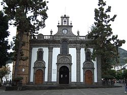
Las Palmas
Provincia de Las Palmas | |
|---|---|
 Map of Spain with Las Palmas highlighted | |
| Coordinates: 28°20′N 14°20′W / 28.333°N 14.333°W | |
| Country | Spain |
| Autonomous community | Canary Islands |
| Capital | Las Palmas de Gran Canaria |
| Area | |
| • Total | 4,065.78 km2 (1,569.81 sq mi) |
| • Rank | Ranked 46th |
| Population (start of 2023) | |
| • Total | 1,145,843 |
| • Rank | Ranked 12th |
| • Density | 280/km2 (730/sq mi) |
| Official language(s) | Spanish |
| Parliament | Cortes Generales |


The Province of Las Palmas (/lɑːs ˈpɑːlməs/, UK: /ˈpɑːməs/; Spanish: Provincia de Las Palmas) is a province of Spain, consisting of the eastern part of the autonomous community of the Canary Islands. Las Palmas de Gran Canaria, capital city of this province and of the island of Gran Canaria, is the largest city in the Canary Islands.
In 1927, the Province of Canary Islands was split into two provinces: Las Palmas and Santa Cruz de Tenerife. In 1982, both provinces became part of the newly founded autonomous community of the Canary Islands.

