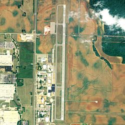
Pryor Field Regional Airport | |||||||||||
|---|---|---|---|---|---|---|---|---|---|---|---|
 2006 USGS airphoto | |||||||||||
| Summary | |||||||||||
| Airport type | Public | ||||||||||
| Owner | Decatur/Athens Airport Authority | ||||||||||
| Serves | Decatur, Alabama | ||||||||||
| Location | Limestone County, Alabama | ||||||||||
| Elevation AMSL | 592 ft / 180 m | ||||||||||
| Coordinates | 34°39′15″N 86°56′43″W / 34.65417°N 86.94528°W | ||||||||||
| Map | |||||||||||
 | |||||||||||
| Runways | |||||||||||
| |||||||||||
| Statistics (2017) | |||||||||||
| |||||||||||
| Designated | December 16, 2010[2] | ||||||||||
Pryor Field Regional Airport (IATA: DCU, ICAO: KDCU, FAA LID: DCU) is a public airport located three miles (5 km) northeast of the central business district of Decatur and south of Athens, in Limestone County, Alabama, United States. It is owned by Decatur/Athens Airport Authority.[1]
Situated next to Calhoun Community College, the airport serves the western portion of the Huntsville-Decatur Combined Statistical Area and most of the Decatur Metropolitan Area. Pryor Field is currently the busiest regional airport in Alabama.[3]
- ^ a b FAA Airport Form 5010 for DCU PDF, effective July 5, 2007
- ^ "Alabama Register of Landmarks & Heritage Listings as of April 7, 2023" (PDF). ahc.alabama.gov. Retrieved 2 February 2024.
- ^ "Rivers, rails, roads, and air". Decatur Daily. October 1, 2006. Archived from the original on May 27, 2007. Retrieved October 26, 2006.

