Puerto Plata
San Felipe de Puerto Plata | |
|---|---|
City | |
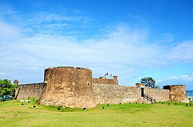
From the top: Panoramic, Downtown, Fort, Street, Christ the Redeemer and San Felipe fort | |
| Nickname: La tacita de plata (the little silver cup) La Novia del Atlántico (The Bride of the Atlantic) | |
| Coordinates: 19°47′14″N 70°41′30″W / 19.78722°N 70.69167°W | |
| Country | Dominican Republic |
| Province | Puerto Plata |
| Founded | 1502 |
| Municipality since | 1844 |
| Area | |
| • Total | 509.01 km2 (196.53 sq mi) |
| Elevation | 8 m (26 ft) |
| Population (2022 census)[3] | |
| • Total | 162,093 |
| • Density | 320/km2 (820/sq mi) |
| • Demonym | Puertoplateño(a) |
| Time zone | UTC-04:00 (AST) |
| Distance to – Santo Domingo | 215 km (134 mi) |
| Municipal Districts | 2 |
| Website | www |
Puerto Plata, officially known as San Felipe de Puerto Plata; (French: Port-de-Plate)[4] is a major coastal city in the Dominican Republic, and capital of the province of Puerto Plata.[5] The city is a major trading port. Puerto Plata has resorts such as Playa Dorada and Costa Dorada, which are located east of the city proper. There are 100,000 hotel beds in the city. The first aerial tramway of the Caribbean is located in Puerto Plata, in which visitors can ride up to the Pico Isabel de Torres, a 793-meter (2600-foot) high mountain within the city.
The city’s history dates back to the early 16th century, when Spanish colonists founded a small colonial settlement in the region. During the first decades of the existence of the Captaincy General of Santo Domingo, the settlement was considered the main commercial and maritime port of the island. In 1605, it was depopulated and destroyed by order of Philip III of Spain to counter raids by English privateers and pirates; a hundred years later, the city was repopulated with farmers from the Canary Islands. From 1822 to 1844 the city was under Haitian control. From 1844 on began the period of the republic, in which the city began to recover its maritime and commercial boom. Beginning in 1865, the current Puerto Plata began to be built. This explains the Victorian style of much of its current architecture. By the end of the 19th century, Puerto Plata had become important for its cultural, social, maritime, and economic development.
- ^ Superficies a nivel de municipios, Oficina Nacional de Estadistica Archived 2009-04-17 at the Wayback Machine
- ^ De la Fuente, Santiago (1976). Geografía Dominicana (in Spanish and English). Santo Domingo, Dominican Republic: Editora Colegial Quisqueyana.
- ^ "Puerto Plata (Municipality, Dominican Republic) - Population Statistics, Charts, Map and Location". www.citypopulation.de. Retrieved 2024-10-10.
- ^ Médéric Louis Élie Moreau de Saint-Méry (1796). "A Topographical and Political Description of the Spanish Part of Saint-Domingo; Containing, General Observations on the Climate, Population and Productions; on the Character and Manners of the Inhabitants; with an Account of the Several Branches of the Government, Volume 1". British Library. p. 38. Retrieved 25 May 2024.
- ^ Expansión Urbana de las ciudades capitales de RD: 1988-2010 (in Spanish). Santo Domingo: Oficina Nacional de Estadística. 1 May 2015. ISBN 978-9945-8984-3-9. Archived from the original on 14 July 2016. Retrieved 25 January 2016.


