Camp
Pune Cantt | |
|---|---|
Cantonment | |
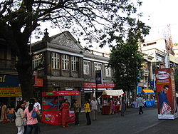
 MG Road in Pune Cantonment | |
| Coordinates: 18°30′45″N 73°59′09″E / 18.51250°N 73.98583°E | |
| Country | |
| State | Maharashtra |
| Region | Paschim Maharashtra |
| Division | Pune |
| District | Pune |
| Established | 1817 |
| Taluka | Haveli taluka |
| Government | |
| • Body | Pune Cantonment Board |
| • Cantonment Executive Officer | Shri. Amit Kumar[1] |
| Area | |
| • Total | 11.9 km2 (4.6 sq mi) |
| Elevation | 577 m (1,893 ft) |
| Population (2005)[2] | |
| • Total | 79,454 |
| • Density | 6,700/km2 (17,000/sq mi) |
| Languages | |
| • Official | Marathi |
| Time zone | UTC+5:30 (IST) |
| PIN | 411 0xx |
| Telephone code | (91)20 |
| Vehicle registration | MH 12, MH 14 |
| Lok Sabha constituency | Pune |
| Vidhan Sabha constituency | Pune Cantonment |
| Civic agency | Pune Cantonment Board |
| Climate | Tropical Wet & Dry (Köppen) |
| Avg. annual temperature | 24 °C (75 °F) |
| Avg. summer temperature | 30 °C (86 °F) |
| Avg. winter temperature | 12 °C (54 °F) |
| Website | pune |
Pune Cantt, also known as Camp, is a military cantonment located in the city of Pune, India. It was established in 1817 for accommodating troops of the Indian Army. The cantonment houses many military establishments. It is also known for its shopping locations, MG Road and East Street. The headquarters of Indian Army's Southern Command is located in Pune Cantonment. The National War Memorial Southern Command which commemorates the sacrifice of soldiers of the Indian Armed Forces is also situated in the cantonment.
- ^ "Welcome to Cantonment Board Pune". Retrieved 20 December 2018.
- ^ "Cities in India". Retrieved 16 January 2010.

