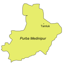

Purba Medinipur (English: East Medinipur, alternative spelling Midnapore) district is an administrative unit in the Indian state of West Bengal. It is the southernmost district of Medinipur division – one of the five administrative divisions of West Bengal. The headquarters in Tamluk. It was formed on 1 January 2002 after the Partition of Medinipur into Purba Medinipur and Paschim Medinipur which lies at the northern and western border of it. The state of Odisha is at the southwest border; the Bay of Bengal lies in the south; the Hooghly river and South 24 Parganas district to the east; Howrah district to the north-east; Paschim Medinipur district to the west.
Purba Medinipur comprises the sub-divisions of Tamluk, Contai and Haldia of erstwhile Medinipur district.[3] Another sub-division, Egra has been created out of the erstwhile Contai sub-division during the partition of Medinipur. In 2011, the state government proposed to rename the district as Tamralipta district after the ancient port city of Tamralipta which used to lie near the modern district headquarters.
Purba Medinipur saw many political movements during the British Raj. A parallel government named the Tamralipta Jatiya Sarkar was formed during the Quit India Movement in Tamluk.[4] In 2007, Purba Medinipur witnessed the Nandigram violence, an incident of police firing that killed 14 farmers.[5]
- ^ a b "Fact and Figures". Wb.gov.in. Retrieved 5 July 2019.
- ^ "52nd Report of the Commissioner for Linguistic Minorities in India" (PDF). Nclm.nic.in. Ministry of Minority Affairs. p. 85. Archived from the original (PDF) on 25 May 2017. Retrieved 5 July 2019.
- ^ Jana, Naresh (31 December 2001). "Tamluk readies for giant's partition". The Telegraph (Kolkata). Archived from the original on 14 March 2014. Retrieved 1 September 2008.
- ^ "Sushil Dhara:Dreams of '42 Service in '90s". janasamachar.net. Retrieved 22 August 2009.
- ^ "Red-hand Buddha: 14 killed in Nandigram re-entry bid". The Telegraph. 15 March 2007. Archived from the original on 4 December 2012. Retrieved 15 March 2007.


