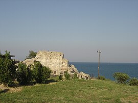
Pydna
Πύδνα | |
|---|---|
 | |
| Coordinates: 40°22′N 22°35′E / 40.367°N 22.583°E | |
| Country | Greece |
| Administrative region | Central Macedonia |
| Regional unit | Pieria |
| Municipality | Pydna-Kolindros |
| Area | |
| • Municipal unit | 105.59 km2 (40.77 sq mi) |
| • Community | 41.334 km2 (15.959 sq mi) |
| Elevation | 78 m (256 ft) |
| Population (2021)[1] | |
| • Municipal unit | 2,591 |
| • Municipal unit density | 25/km2 (64/sq mi) |
| • Community | 1,085 |
| • Community density | 26/km2 (68/sq mi) |
| Time zone | UTC+2 (EET) |
| • Summer (DST) | UTC+3 (EEST) |
| Postal code | 600 64 |
| Area code(s) | 23510 |
| Vehicle registration | KN |
Pydna (/ˈpɪdnə/; Greek: Πύδνα, Pýdna) is a small town and a former municipality in the northeastern part of Pieria regional unit, Greece. Since the 2011 local government reform it is part of the municipality Pydna-Kolindros, of which it is a municipal unit.[2] The municipal unit has an area of 105.059 km2, the community 41.334 km2.[3] Pydna is situated in fertile land close to the Thermaic Gulf coast. The main village of the former municipality is Kitros. It lies 6 km north of Korinos, 8 km south of Methoni and 13 km northeast of Katerini. The A1 motorway and the Piraeus–Platy railway (nearest station at Korinos) pass east of the village.
- ^ "Αποτελέσματα Απογραφής Πληθυσμού - Κατοικιών 2021, Μόνιμος Πληθυσμός κατά οικισμό" [Results of the 2021 Population - Housing Census, Permanent population by settlement] (in Greek). Hellenic Statistical Authority. 29 March 2024.
- ^ "ΦΕΚ B 1292/2010, Kallikratis reform municipalities" (in Greek). Government Gazette.
- ^ "Population & housing census 2001 (incl. area and average elevation)" (PDF) (in Greek). National Statistical Service of Greece.

