This article possibly contains original research. (October 2014) |
| Pymatuning State Park | |
|---|---|
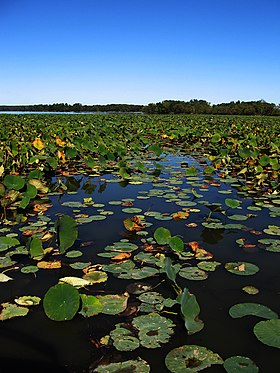
 Lily pads on Pymatuning Lake | |
| Location | Ashtabula County, Ohio, United States |
| Nearest city | Andover, Ohio |
| Coordinates | 41°38′49″N 80°31′33″W / 41.64694°N 80.52583°W[1] |
| Area | 3,512 acres (1,421 ha)[2] |
| Elevation | 1,004 feet (306 m)[1] |
| Established | 1950[3] |
| Administered by | Ohio Department of Natural Resources |
| Designation | Ohio state park |
| Website | Pymatuning State Park |
Pymatuning State Park is a 3512 acres (14.21 km2) Ohio state park near Andover, Ashtabula County, Ohio in the United States. Pymatuning State Park contains 1,407 acres (5.69 km2) of Pymatuning Lake, one-quarter of which is in Ohio and three-quarters of which is in Pennsylvania.[4] The lake provides fishing and boating year round.[3]
Formed in the 1930s by a dam on the Shenango River, the lake features multiple beaches and camping areas in both states. The northeastern part of Pymatuning Lake, east of the spillway and three miles (5 km) south of Linesville, is a protected gameland where colonies of 20,000 Canada geese and many more ducks winter each year. The lake is the result of an earth dam three miles (5 km) north of Jamestown, Pennsylvania, whose outflow forms the Shenango River. A three-mile (5 km) causeway extends between Pennsylvania and Ohio near the center of the lake.
- ^ a b "Pymatuning State Park". Geographic Names Information System. United States Geological Survey, United States Department of the Interior.
- ^ Cite error: The named reference
odnr2007was invoked but never defined (see the help page). - ^ a b Cite error: The named reference
odnrwas invoked but never defined (see the help page). - ^ Cite error: The named reference
lakeswas invoked but never defined (see the help page).

