

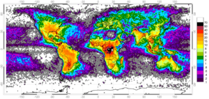
Pyrogeography is the study of the past, present, and projected distribution of wildfire. Wildland fire occurs under certain conditions of climate, vegetation, topography, and sources of ignition, such that it has its own biogeography, or pattern in space and time.[1][2] The earliest published evidence of the term appears to be in the mid-1990s, and the meaning was primarily related to mapping fires[3][4] The current understanding of pyrogeography emerged in the 2000s as a combination of biogeography and fire ecology, facilitated by the availability of global-scale datasets of fire occurrence, vegetation cover, and climate. Pyrogeography has also been placed at the juncture of biology, the geophysical environment, and society and cultural influences on fire.[5]
Pyrogeography often uses a framework of ecological niche concepts to evaluate the environmental controls on fire. By examining how environmental factors interact to facilitate fire activity, pyrogeographers can predict expected fire behavior under new conditions. Pyrogeographic research contributes to and informs land management policy in various regions across the globe.
- ^ Krawchuk MA, Moritz MA, Parisien MA, Van Dorn J, Hayhoe K (April 2009). "Global pyrogeography: the current and future distribution of wildfire". PLOS ONE. 4 (4): e5102. Bibcode:2009PLoSO...4.5102K. doi:10.1371/journal.pone.0005102. PMC 2662419. PMID 19352494.
- ^ Krawchuk MA, Moritz MA (July 2014). "Burning issues: statistical analyses of global fire data to inform assessments of environmental change". Environmetrics. 25 (6): 472–481. doi:10.1002/env.2287. ISSN 1180-4009. S2CID 117838440.
- ^ Sannikov SN (1994). "Evolutionary pyroecology and pyrogeography of the natural regeneration of Scots Pine". Proceedings of Forest Fire Research: 961–968.
- ^ Yool SR (June 1999). Gottfried GJ, Eskew LG, Curtin CG, Edminster CB (eds.). "Remote sensing fire studies in the Greater Borderlands" (PDF). Toward Integrated Research, Land Management, and Ecosystem Protection in the Malpai Borderlands: Conference Summary. USDA Forest Service Proceedings: 88–92. RMRS-P-10.
- ^ Bowman DM, O'Brien JA, Goldammer JG (October 2013). "Pyrogeography and the Global Quest for Sustainable Fire Management". Annual Review of Environment and Resources. 38 (1): 57–80. doi:10.1146/annurev-environ-082212-134049. ISSN 1543-5938.