Qalhāt
Arabic: قلهات | |
|---|---|
 | |
 | |
| Coordinates: 22°41′58″N 59°22′10″E / 22.69944°N 59.36944°E | |
| Country | Oman |
| Governorate | Ash Sharqiyah South Governorate |
| Wilayat | Wilayat of Sur |
| Population (2010) | |
| • Total | 1,123 |
| UNESCO World Heritage Site | |
|---|---|
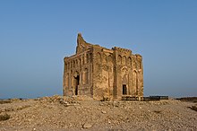
 Bibi Maryam mausoleum | |
| Location | Sur Province, Ash Sharqiyah South Governorate, Oman |
| Criteria | Cultural: (ii), (iii) |
| Reference | 1537 |
| Inscription | 2018 (42nd Session) |
| Area | 75.82 ha |
| Buffer zone | 170.09 ha |
| Coordinates | 22°42′N 59°22′E / 22.700°N 59.367°E |
Qalhāt (Arabic: قلهات) is a village in Oman, over 20 km north of Sur. The residential area is to the northwest of Wādī Ḥilm (Arabic: وادي حلم), and the ruins of the ancient city are located to the southeast. The ancient city is referred to as Calatu by Marco Polo and as Calha in the map of Abraham Ortelius.

