Qingshan
青山区 | ||||||||||||||||||||||||||||||||||||
|---|---|---|---|---|---|---|---|---|---|---|---|---|---|---|---|---|---|---|---|---|---|---|---|---|---|---|---|---|---|---|---|---|---|---|---|---|
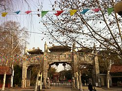
 Qingshan Park Main Gate | ||||||||||||||||||||||||||||||||||||
 | ||||||||||||||||||||||||||||||||||||
| Coordinates: 30°37′51″N 114°24′17″E / 30.6307°N 114.4046°E[1] | ||||||||||||||||||||||||||||||||||||
| Country | People's Republic of China | |||||||||||||||||||||||||||||||||||
| Province | Hubei | |||||||||||||||||||||||||||||||||||
| Sub-provincial city | Wuhan | |||||||||||||||||||||||||||||||||||
| Area | ||||||||||||||||||||||||||||||||||||
| • Total | 68.40 km2 (26.41 sq mi) | |||||||||||||||||||||||||||||||||||
| Population (2010)[3] | ||||||||||||||||||||||||||||||||||||
| • Total | 485,375 | |||||||||||||||||||||||||||||||||||
| • Density | 7,096/km2 (18,380/sq mi) | |||||||||||||||||||||||||||||||||||
| Time zone | UTC+8 (China Standard) | |||||||||||||||||||||||||||||||||||
| Wuhan district map |
| |||||||||||||||||||||||||||||||||||
| Website | Official Site | |||||||||||||||||||||||||||||||||||
Qingshan District (simplified Chinese: 青山区; traditional Chinese: 青山區; pinyin: Qīngshān Qū; lit. 'azure mountain') forms part of the urban core of and is one of 13 urban districts of the prefecture-level city of Wuhan, the capital of Hubei Province, China. On the right bank of the Yangtze, it borders the districts of Wuchang (for a very small section) to the southwest and Hongshan to the east and south, except for Tianxing Island which lies due north of Qingshan; on the opposite bank it borders Jiang'an.
Qingshan District has been described as Wuhan's industrial hub.[4]
- ^ "Qingshan" (Map). Google Maps. Retrieved 2014-07-02.
- ^ "Wuhan Statistical Yearbook 2010" (PDF). Wuhan Statistics Bureau. p. 15. Archived from the original (PDF) on November 5, 2011. Retrieved 2011-07-31.
- ^ "武汉市2010年第六次全国人口普查主要数据公报" (in Chinese). Wuhan Statistics Bureau. 2011-05-11. Archived from the original on 2011-10-25. Retrieved 2011-06-11.
- ^ "Riverfront industrial town transformed into eco-city-Xinhua". english.news.cn. Retrieved 2024-08-07.

