| Quinnipiac River Dragon River, East River, New Haven River[1] | |
|---|---|
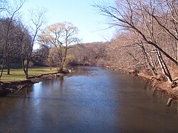
 The Quinnipiac River, as seen looking west (upstream) from "Red Bridge" in Meriden, Connecticut | |
 | |
| Location | |
| Country | United States |
| State | Connecticut |
| Region | New Haven, Hartford |
| District | North Haven, Wallingford, Cheshire, Southington, Plainville |
| Cities | New Haven, Meriden |
| Physical characteristics | |
| Source | Deadwood Swamp |
| • location | Farmington, Connecticut, Hartford County, Connecticut, United States |
| • coordinates | 41°41′42″N 072°48′55″W / 41.69500°N 72.81528°W[3] |
| • elevation | 335 ft (102 m) |
| Mouth | New Haven Harbor, New Haven, Connecticut |
• location | Long Island Sound, New Haven County, Connecticut, United States |
• coordinates | 41°17′58″N 072°54′14″W / 41.29944°N 72.90389°W[3] |
• elevation | 0 ft (0 m) |
| Length | 45.5 mi (73.2 km) |
| Discharge | |
| • location | mouth |
| • average | 414 cu ft/s (11.7 m3/s) (estimate)[2] |
The Quinnipiac River (/ˈkwɪnəˌpi.æk/ KWIH-nə-pee-ak) is a 45.5-mile (73.2 km)[4] long river in the New England region of the United States, located entirely in the state of Connecticut.
The river rises in West Central Connecticut from Dead Wood Swamp near the city of New Britain. It flows roughly southward to Plainville, Southington, and Cheshire, west of the city of Meriden, through Wallingford and Yalesville, North Haven, and flows into New Haven Harbor, an inlet of Long Island Sound, east of downtown New Haven.
- ^ Hughes, Arthur; Morse S. Allen (1976). Connecticut Place Names. Hartford, Connecticut: The Connecticut Historical Society. p. 364.
- ^ United States Environmental Protection Agency. "Watershed Report: Quinnipiac River". WATERS GeoViewer. Archived from the original on 2021-09-13. Retrieved 2021-09-13.
- ^ a b "Quinnipiac River". Geographic Names Information System. United States Geological Survey, United States Department of the Interior.
- ^ U.S. Geological Survey. National Hydrography Dataset high-resolution flowline data. The National Map Archived 2012-03-29 at the Wayback Machine, accessed April 1, 2011