Rabat
الرباط | |
|---|---|
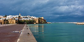
Clockwise from top: River Bou Regreg and the Kasbah of the Udayas, Royal Palace, Hassan Tower, Avenue Mohammed V in downtown Rabat, Chellah Necropolis, Mausoleum of Mohammed V. | |
| Coordinates: 34°02′N 6°50′W / 34.033°N 6.833°W[1] | |
| Country | Morocco |
| Region | Rabat-Salé-Kénitra |
| Government | |
| • Mayor | Fatiha El Moudni |
| Area | |
| • Capital city | 117 km2 (45.17 sq mi) |
| Highest elevation | 160 m (520 ft) |
| Lowest elevation | 0 m (0 ft) |
| Population (2014)[2] | |
| • Capital city | 1,800,000 |
| • Rank | 7th in Morocco |
| • Density | 15,000/km2 (40,000/sq mi) |
| • Metro | 2,120,192 |
| Time zone | UTC+1 (CET) |
| Website | mairiederabat |
| Official name | Rabat, Modern Capital and Historic City: a Shared Heritage |
| Type | Cultural |
| Criteria | ii, iv |
| Designated | 2012 (36th session) |
| Reference no. | 1401 |
| Region | Arab States |
Rabat (/rəˈbɑːt/, also UK: /rəˈbæt/, US: /rɑːˈbɑːt/;[3][4][5] Arabic: الرباط, romanized: ar-Ribāṭ) is the capital city of Morocco and the country's seventh-largest city with an urban population of approximately 580,000 (2014)[2] and a metropolitan population of over 1.2 million. It is also the capital city of the Rabat-Salé-Kénitra administrative region.[6] Rabat is located on the Atlantic Ocean at the mouth of the river Bou Regreg, opposite Salé, the city's main commuter town.
Rabat was founded in the 12th century by the Almohads. After a period of growth, the city fell into a long period of decline. In the 17th century, Rabat became a haven for Barbary pirates. When the French established a protectorate over Morocco in 1912, Rabat became its administrative center. When Morocco achieved independence in 1955 Rabat became its capital.
Rabat, Temara, and Salé form a conurbation of over 1.8 million people. Rabat is one of four Imperial cities of Morocco, and its medina is listed as a World Heritage Site. It is accessible by train through the ONCF system and by plane through the nearby Rabat–Salé Airport.
- ^ "Hong Kong Observatory". Hong Kong Observatory. Retrieved 2009-08-17.
- ^ a b "Population légale d'après les résultats du RGPH 2014 sur le Bulletin officiel N° 6354". Haut-Commissariat au Plan (in Arabic). Archived from the original (pdf) on 2018-12-26. Retrieved 2015-07-11.
- ^ "Rabat". The American Heritage Dictionary of the English Language (5th ed.). HarperCollins. Retrieved 7 May 2019.
- ^ "Rabat". Collins English Dictionary. HarperCollins. Retrieved 7 May 2019.
- ^ "Rabat" (US) and "Rabat". Lexico UK English Dictionary. Oxford University Press. Archived from the original on 2020-03-22.
- ^ "Décret fixant le nom des régions" (PDF). Portail National des Collectivités Territoriales (in French). Archived from the original (PDF) on 2015-05-18. Retrieved 2015-07-11.


