Rabo de Peixe | |
|---|---|
 The main harbour and port of Rabo de Peixe, the life-blood of the community | |
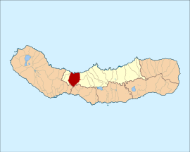
 Location of the civil parish of Rabo de Peixe in the municipality of Ribeira Grande | |
| Coordinates: 37°48′37″N 25°35′10″W / 37.81028°N 25.58611°W | |
| Country | |
| Auton. region | Azores |
| Island | São Miguel |
| Municipality | Ribeira Grande |
| Established | Settlement: c. 1500 Town: 2004 |
| Area | |
| • Total | 16.96 km2 (6.55 sq mi) |
| Elevation | 43 m (141 ft) |
| Population (2011) | |
| • Total | 8,866 |
| • Density | 520/km2 (1,400/sq mi) |
| Time zone | UTC−01:00 (AZOT) |
| • Summer (DST) | UTC±00:00 (AZOST) |
| Postal code | 9600-124 |
| Area code | 292 |
| Patron | Senhor Bom Jesus |
| Website | www |
Rabo de Peixe (Portuguese for "fish tail") is a civil parish in the municipality of Ribeira Grande in the Portuguese archipelago of the Azores. The population in 2011 was 8,866,[1] in an area of 16.96 km2.[2] It is the most populous and most densely populated parish in the municipality. It contains the localities Charco, Custódio, Labardas, Nogueira, Pico da Madeira, Pico da Varanda, Pico do Bode, Pico do Refugio, Rebentão, Santana, São Sebastião, Senhora da Conceição and Tulha.

