| Radstadt Tauern | |
|---|---|
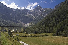
 Tauern Autobahn near Flachau | |
| Highest point | |
| Peak | Weißeck |
| Elevation | 2,711 m (8,894 ft) |
| Coordinates | 47°09′46″N 13°23′38″E / 47.16278°N 13.39389°E |
| Geography | |
| Country | Austria |
| State | Salzburg |
| Range coordinates | 47°09′00″N 13°23′00″E / 47.15000°N 13.38333°E |
| Parent range | Central Eastern Alps Low Tauern |
The Radstadt Tauern[1][2][3][4][5] (German: Radstädter Tauern) are a subrange of the Central Eastern Alps in Austria. Together with the Schladming Tauern, the Rottenmann and Wölz Tauern and the Seckau Tauern the Radstadt Tauern form the major range of mountains known as the Low Tauern. The mountains are found in the southeast of the Austrian state of Salzburg, between the upper reaches of the Enns and Mur rivers.
- ^ Outline of the geology of Austria and selected excursions, Volumes 34-35. Geologische Bundesanstalt (Austria), 1980. p. 60ff. ISBN 978-3-9003-1207-7.
- ^ Comite national francais de geologie (1980), Geology of the European countries: Austria, Federal Republic of Germany, Ireland, The Netherlands, Switzerland, United Kingdom, Dunod, Univ. of Michigan, 1980, pp. 35ff. ISBN 978-0-8601-0261-8
- ^ Karl Baedeker (1879). The eastern Alps, including the Bavarian highlands, the Tyrol, Salzkammergut, Styria, and Carinthia, Baedeker, p. 328.
- ^ Fodor (1992). Fodor's Austria, Fodor, pp. 309/10, D. McKay.
- ^ The Schladming Tauern at travel.michelin.com. Accessed on 10 Mar 2013.
