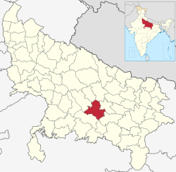
Raebareli district | |
|---|---|
 AIIMS Raebareli Residential Complex | |
 Location of Raebareli district in Uttar Pradesh | |
| Coordinates (Raebareli): 26°13′48″N 81°14′24″E / 26.23000°N 81.24000°E | |
| Country | |
| State | Uttar Pradesh |
| Division | Lucknow |
| Established | 1858 |
| Headquarters | Raebareli |
| Government | |
| • Lok Sabha constituencies |
|
| • Vidhan Sabha constituencies[1] | |
| Area | |
| • Total | 3,371 km2 (1,302 sq mi) |
| Population (2011) | |
| • Total | 2,903,507 |
| • Density | 860/km2 (2,200/sq mi) |
| Demographics | |
| • Literacy | 67.25% |
| • Sex ratio | 943 |
| Time zone | UTC+05:30 (IST) |
| Major highways | NH30, NH31, NH330A, NH128, NH335 |
| Website | raebareli |
Raebareli district is a district of Uttar Pradesh state in northern India. The city of Raebareli is the district headquarters. This district is a part of Lucknow Division in Uttar Pradesh state. The total area of Raebareli district is 3,371 Sq. km.[2]
As of 2011, its population is 3,405,559, which makes it the 27th largest in the state.[3] It is a predominantly rural district, with 91% of the population living in rural areas.[3]
- ^ "Constituencies". Retrieved 6 December 2018.
- ^ "District Raebareli, Government of Uttar Pradesh | Land of Martyrs | India". Retrieved 8 March 2021.
- ^ a b "Census of India 2011: Uttar Pradesh District Census Handbook - Rae Bareli, Part A (Village and Town Directory)" (PDF). Census 2011 India. pp. xiii–xv, 5–10, 17–8, 28–65, 74, 90, 108, 125, 142, 158, 168, 185, 202, 219, 244, 262, 288, 306, 331, 348, 365, 375, 393, 410, 427, 573–92. Retrieved 22 July 2021.