Ralston, Nebraska | |
|---|---|
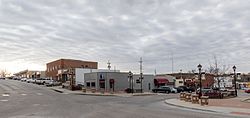
 Main Street in Ralston, March 2017 | |
 Location of Ralston within Nebraska and Douglas County | |
| Coordinates: 41°12′02″N 96°02′08″W / 41.20056°N 96.03556°W | |
| Country | United States |
| State | Nebraska |
| County | Douglas |
| Government | |
| • Mayor | Donald A. Groesser |
| Area | |
| • Total | 1.60 sq mi (4.14 km2) |
| • Land | 1.59 sq mi (4.11 km2) |
| • Water | 0.01 sq mi (0.03 km2) |
| Elevation | 1,093 ft (333 m) |
| Population (2020) | |
| • Total | 6,494 |
| • Density | 4,085.53/sq mi (1,580.04/km2) |
| Time zone | UTC-6 (Central (CST)) |
| • Summer (DST) | UTC-5 (CDT) |
| ZIP code | 68127 |
| Area code(s) | 402 and 531 |
| FIPS code | 31-40605 |
| GNIS feature ID | 2396309[2] |
| Website | http://cityofralston.com/ |
Ralston is a city in Douglas County, Nebraska, United States. The population was 6,494 at the 2020 census. A suburb of Omaha, Ralston is surrounded on three sides by the city of Omaha by 84th, 72nd, and L Streets, and by Sarpy County (Harrison Street) on the south side.
- ^ "ArcGIS REST Services Directory". United States Census Bureau. Retrieved September 18, 2022.
- ^ a b U.S. Geological Survey Geographic Names Information System: Ralston, Nebraska
