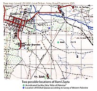
Raml Zayta
رمل زيتة Raml Zeita (Khirbat Qazaza) | |
|---|---|
Village | |
 | |
A series of historical maps of the area around Raml Zayta (click the buttons) | |
Location within Mandatory Palestine | |
| Coordinates: 32°25′42″N 34°58′17″E / 32.42830°N 34.97128°E | |
| Palestine grid | 145/203 |
| Geopolitical entity | Mandatory Palestine |
| Subdistrict | Tulkarm |
| Date of depopulation | 15 March 1948 |
| Population (1945) | |
| • Total | 140[1] |
| Current Localities | Sde Yitzhak,[2] Chadera[2] |
Raml Zayta (Arabic: رمل زيتة, Raml Zeitâ), also Khirbet Qazaza, was a Palestinian Arab village located 15 km northwest of Tulkarm.[3]


