Rampurhat | |
|---|---|
City | |
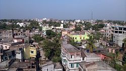
 Aerial view of Rampurhat | |
| Coordinates: 24°10′N 87°47′E / 24.17°N 87.78°E | |
| Country | |
| State | West Bengal |
| District | Birbhum |
| Government | |
| • Type | Municipality |
| • Body |
|
| • MP | Satabdi Roy |
| • MLA | Asish Banerjee |
| Area | |
| • City | 16.32 km2 (6.30 sq mi) |
| • Metro | 95.79 km2 (36.98 sq mi) |
| Population (2011)[3] | |
| • City | 57,833 |
| • Density | 3,500/km2 (9,200/sq mi) |
| Time zone | UTC+5:30 (IST) |
| PIN | 731224 (Rampurhat Head Post Office) |
| Telephone/STD code | +91-03461 (Rampurhat Telephone Exchange) |
| Vehicle registration | WB45/WB46 (Rampurhat RTO) |
| Lok Sabha constituency | 42, Birbhum |
| Vidhan Sabha constituency | Rampurhat, Hansan |
| Website | birbhum |
| rampurhatmunicipality | |
Rampurhat is an important city and a municipality in Birbhum district in the Indian state of West Bengal. It is the headquarters of the Rampurhat subdivision. According to Census 2011 Rampurhat is the third most populous city in Birbhum district and 82nd most populous city in West Bengal.Rampurhat is a rapidly growing township It is near the West Bengal / Jharkhand border. Rampuhat has dynamic connectivity with the other places of West Bengal and neighboring states via state highways, national highway and rail route. Rampurhat Junction is 7th most busiest railway stations in eastern India.
- ^ "Municipalities Name". Archived from the original on 14 May 2016. Retrieved 8 May 2016.
- ^ "TRDA".
- ^ "Census of India Search details". censusindia.gov.in. Retrieved 10 May 2015.

