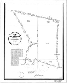
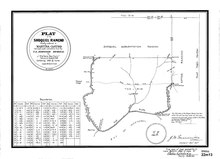
Rancho Soquel was a 1,668-acre (6.75 km2) Mexican land grant in present-day Santa Cruz County, California given in 1833 by Governor José Figueroa to María Martina Castro y Amador.[1] In 1844, Martina Castro was granted by Governor José Figueroa a further 32,702-acre (132.34 km2) grant known as the Soquel Augmentation.[2][3] The Rancho Soquel grant along Monterey Bay includes present-day Soquel and Capitola.[4] Rancho Aptos of her brother Rafael Castro formed the south boundary of the grant. The much-larger Soquel Augmentation grant lay inland from both of these, and comprised mainly mountain watershed land.
- ^ U.S. Geological Survey Geographic Names Information System: Rancho Soquel
- ^ U.S. Geological Survey Geographic Names Information System: Rancho Soquel Augmentation
- ^ Ogden Hoffman, 1862, Reports of Land Cases Determined in the United States District Court for the Northern District of California, Numa Hubert, San Francisco
- ^ Diseño del Rancho Soquel