Rapperswil | |
|---|---|
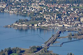
 Rapperswil as seen from Etzel mountain: Capuchin monastery to the left, Rapperswil castle and St. John's church in the background, Lake Zurich harbour and Altstadt in the foreground respectively Seedamm, wooden bridge and upper Lake Zurich to the right (October 2010) | |
| Coordinates: 47°13.6′N 8°49′E / 47.2267°N 8.817°E | |
| Country | Switzerland |
| Canton | St. Gallen |
| District | See-Gaster |
| Municipality | Rapperswil-Jona |
| Government | |
| • Mayor | Stadtpräsident/Stadtammann (list) |
| Area | |
| • Total | 1.74 km2 (0.67 sq mi) |
| Elevation | 409 m (1,342 ft) |
| Population (31 December 2018)[1] | |
| • Total | 2,618 |
| • Density | 1,500/km2 (3,900/sq mi) |
| Time zone | UTC+01:00 (Central European Time) |
| • Summer (DST) | UTC+02:00 (Central European Summer Time) |
| Postal code(s) | 8640 |
| SFOS number | 3336 |
| ISO 3166 code | CH-SG |
| Surrounded by | Altendorf (SZ), Freienbach (SZ), Jona, Bollingen, Lachen (SZ) |
| Website | www SFSO statistics |
Rapperswil (Swiss German: [ˈrɑpːərʃˌʋiːl] or [ˈrɑpːərsˌʋiːl];[2] short: Rappi) is a former municipality and since January 2007 part of the municipality of Rapperswil-Jona in the Wahlkreis (constituency) of See-Gaster in the canton of St. Gallen in Switzerland, located between Obersee and the main part of Lake Zurich.
- ^ . Federal Statistical Office https://www.pxweb.bfs.admin.ch/pxweb/de/. Retrieved 15 June 2020.
{{cite web}}: Missing or empty|title=(help) - ^ Andres Kristol, Rapperswil SG (See) in: Dictionnaire toponymique des communes suisses – Lexikon der schweizerischen Gemeindenamen – Dizionario toponomastico dei comuni svizzeri (DTS|LSG), Centre de dialectologie, Université de Neuchâtel, Verlag Huber, Frauenfeld/Stuttgart/Wien 2005, ISBN 3-7193-1308-5 and Éditions Payot, Lausanne 2005, ISBN 2-601-03336-3, p. 727.


