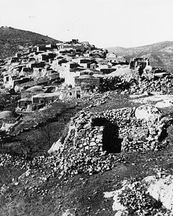
Ras Abu 'Ammar
رأس أبو عمار | |
|---|---|
 Ras Abu 'Ammar 1948 | |
| Etymology: The hill top of Abu Ammar[1] | |
A series of historical maps of the area around Ras Abu 'Ammar (click the buttons) | |
Location within Mandatory Palestine | |
| Coordinates: 31°44′17″N 35°05′33″E / 31.73806°N 35.09250°E | |
| Palestine grid | 158/127 |
| Geopolitical entity | Mandatory Palestine |
| Subdistrict | Jerusalem |
| Date of depopulation | October 21, 1948[4] |
| Area | |
| • Total | 8,342 dunams (8.342 km2 or 3.221 sq mi) |
| Population (1945) | |
| • Total | 620[2][3] |
| Cause(s) of depopulation | Military assault by Yishuv forces |
| Current Localities | Tzur Hadassah[5] |
Ras Abu 'Ammar (Arabic: رأس أبو عمار) was a small Palestinian Arab village in the Jerusalem Subdistrict. It was depopulated during the 1948 Arab-Israeli War on October 21, 1948, by the Har'el Brigade of Operation ha-Har. It was located 14 km west of Jerusalem, surrounded on three sides by the Wadi al-Sarar.


