Rathangan
Irish: Ráth Iomgháin | |
|---|---|
Town | |
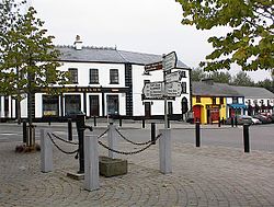
 Town centre | |
| Coordinates: 53°13′18″N 6°59′50″W / 53.22163°N 6.99730°W | |
| Country | Ireland |
| Province | Leinster |
| County | County Kildare |
| Population | 3,263 |
| Time zone | UTC+0 (WET) |
| • Summer (DST) | UTC-1 (IST (WEST)) |
| Irish Grid Reference | N668196 |
| Website | www |
Rathangan (/ræˈθæŋɡən/; Irish: Ráth Iomgháin, meaning 'Iomghan's Fort'[2]) is a town in the west of County Kildare, Ireland. As of 2022[update], the population was 3,263.[1] It is located 65 km (40 mi) from the centre of Dublin, and 14 km (8.7 mi) from Kildare, at the intersection of the R401, R414, and R419 regional roads.[3] The Slate River and the Grand Canal run through the town. The town is in a townland and civil parish of the same name.[2]
Rathangan is situated beside the Bog of Allen, and is in close proximity to the lowlands of the Curragh. In recent years,[when?] the town has grown significantly to become a big commuter base for people working in Dublin.[citation needed]
- ^ a b "Census 2022 - F1015 Population". Central Statistics Office Census 2022 Reports. Central Statistics Office Ireland. August 2023. Retrieved 16 September 2023.
- ^ a b "Ráth Iomgháin/Rathangan". Placenames Database of Ireland (logainm.ie). Government of Ireland. Retrieved 5 October 2021.
- ^ Google Map showing Rathangan
