| Rattlesnake Fire | |
|---|---|
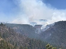
 Smoke rising from the Rattlesnake Fire, April 13, 2018 | |
| Date(s) | April 11 – May 27, 2018 |
| Location | Navajo and Utah Counties, Arizona, US |
| Coordinates | 33°39′22″N 109°30′22″W / 33.656°N 109.506°W |
| Statistics | |
| Burned area | 26,072 acres (10,551 ha; 40.738 sq mi) |
| Impacts | |
| Non-fatal injuries | 15 |
| Damage | $11.4 million |
| Ignition | |
| Cause | Unknown |
| Map | |
The Rattlesnake Fire was a wildfire that burned 26,072 acres (10,551 ha) in Navajo and Greenlee Counties, in Arizona. The fire was detected on April 11, 2018, on the Fort Apache Indian Reservation and spread onto the San Carlos Indian Reservation and Apache-Sitgreaves National Forests over the following four days. Fanned by high winds, the Rattlesnake Fire spread rapidly until it was contained on May 1. The fire continued to burn within containment until May 27. No structures were damaged or destroyed by the fire, but 15 firefighters were injured. Investigators suspected the cause of the fire was human activity, but it was never determined with certainty.

