Rawene | |
|---|---|
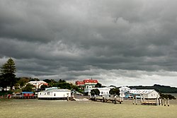
 Rawene, as viewed from the water | |
 | |
| Coordinates: 35°23′46″S 173°30′18″E / 35.39611°S 173.50500°E | |
| Country | New Zealand |
| Region | Northland Region |
| District | Far North District |
| Ward | Kaikohe/Hokianga |
| Electorates | |
| Government | |
| • Territorial Authority | Far North District Council |
| • Regional council | Northland Regional Council |
| Area | |
| • Total | 2.15 km2 (0.83 sq mi) |
| Population (June 2023)[2] | |
| • Total | 540 |
| • Density | 250/km2 (650/sq mi) |
Rawene is a town on the south side of the Hokianga harbour, in Northland, New Zealand. State Highway 12 passes to the south.[3] The town lies at the apex of a peninsula. A car ferry links it to Kohukohu and the northern Hokianga.[4]
- ^ Cite error: The named reference
Areawas invoked but never defined (see the help page). - ^ "Subnational population estimates (RC, SA2), by age and sex, at 30 June 1996-2023 (2023 boundaries)". Statistics New Zealand. Retrieved 25 October 2023. (regional councils); "Subnational population estimates (TA, SA2), by age and sex, at 30 June 1996-2023 (2023 boundaries)". Statistics New Zealand. Retrieved 25 October 2023. (territorial authorities); "Subnational population estimates (urban rural), by age and sex, at 30 June 1996-2023 (2023 boundaries)". Statistics New Zealand. Retrieved 25 October 2023. (urban areas)
- ^ Roger Smith, GeographX (2005). The Geographic Atlas of New Zealand. Robbie Burton. map 22. ISBN 1-877333-20-4.
- ^ "Hokianga district". Te Ara: The Encyclopedia of New Zealand.