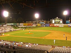
 Travelers game against the Tulsa Drillers in August 2006. | |
 | |
| Former names | Traveler Field (1932-1966) |
|---|---|
| Location | 400 Broadway Street Little Rock, Arkansas 72201 |
| Coordinates | 34°44′43″N 92°19′39″W / 34.74528°N 92.32750°W |
| Owner | City of Little Rock |
| Operator | Arkansas Travelers Baseball, Inc. |
| Capacity | 6,083 |
| Field size | Left Field: 330 feet Center Field: 390 feet Right Field: 345 feet |
| Surface | Grass |
| Construction | |
| Broke ground | 1931 |
| Opened | April 13, 1932 |
| Closed | September 3, 2006 |
| Demolished | 2012 |
| Construction cost | $100,000 ($2.23 million in 2023 dollars[1]) |
| Architect | Thompson, Sanders & Ginocchio |
| General contractor | McGregor & Pickett |
| Tenants | |
| Little Rock Travelers (SA) (1932–1961) Arkansas Travelers (TL) (1963–2006) | |
Ray Winder Field was a baseball park in Little Rock, Arkansas. The ballpark sat with home plate in roughly the north-northwest corner of the property. The former boundaries of the park were Interstate 630 (south, right field); Jonesboro Drive (west, right field corner); South Monroe Street (west, first base stands); buildings on driveway extended from Ray Winder Drive (north, third base stands); buildings bordering South Palm Street (east, right field). The field was in operation for around 74 years.
- ^ 1634–1699: McCusker, J. J. (1997). How Much Is That in Real Money? A Historical Price Index for Use as a Deflator of Money Values in the Economy of the United States: Addenda et Corrigenda (PDF). American Antiquarian Society. 1700–1799: McCusker, J. J. (1992). How Much Is That in Real Money? A Historical Price Index for Use as a Deflator of Money Values in the Economy of the United States (PDF). American Antiquarian Society. 1800–present: Federal Reserve Bank of Minneapolis. "Consumer Price Index (estimate) 1800–". Retrieved February 29, 2024.