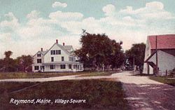
Raymond, Maine | |
|---|---|
 Village square in 1906 | |
 Location in Cumberland County and the state of Maine. | |
| Coordinates: 43°55′10″N 70°28′0″W / 43.91944°N 70.46667°W | |
| Country | United States |
| State | Maine |
| County | Cumberland |
| Incorporated | 1803 |
| Villages | Raymond East Raymond North Raymond |
| Area | |
| • Total | 44.75 sq mi (115.90 km2) |
| • Land | 33.18 sq mi (85.94 km2) |
| • Water | 11.57 sq mi (29.97 km2) |
| Elevation | 312 ft (95 m) |
| Population (2020) | |
| • Total | 4,536 |
| • Density | 137/sq mi (52.8/km2) |
| Time zone | UTC-5 (Eastern (EST)) |
| • Summer (DST) | UTC-4 (EDT) |
| ZIP code | 04071 |
| Area code | 207 |
| FIPS code | 23-61945 |
| GNIS feature ID | 0582692 |
| Website | www |
Raymond is a town in Cumberland County, Maine, United States. Raymond is included in the Lewiston-Auburn, Maine metropolitan New England city and town area. The population was 4,536 at the 2020 census.[2] It is a summer recreation area and is part of the Portland–South Portland–Biddeford, Maine metropolitan statistical area. Raymond Neck is the landing for the ferry to the town of Frye Island in Sebago Lake. The Raymond school system is currently affiliated with the Windham school system in a district known as RSU 14.
- ^ Cite error: The named reference
Gazetteer fileswas invoked but never defined (see the help page). - ^ "Census - Geography Profile: Raymond town, Cumberland County, Maine". United States Census Bureau. Retrieved January 13, 2022.